Traverse (Optional Module)
Use the optional Traverse module to check control points, add control points, or to establish benchmarks around the project. The Traverse feature requires you set up on a known point and have at least one other known control point. These points must be established as control points with the triangle symbol under the Point Manager tool.
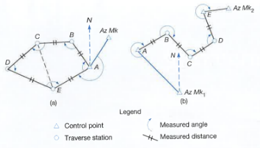
There are two types of mathematically closed Traverse that are supported in FieldLink, Polygon and Link:
-
In the Polygon traverse, as shown in Figure (a), the lines return to the starting point, thus forming a closed figure that is both geometrically and mathematically closed.
-
Link traverses finish upon another station that should have a positional accuracy equal to or greater than that of the starting point. The link type (geometrically open, mathematically closed), is illustrated in Figure (b).
To conduct a traverse
- Tap the Device icon
 and then tap Traverse. A message will appear telling you to “Select and position the instrument over a known control point”.
- Tap on the point for the desired instrument location.
- A message will then appear telling you to “Configure the targets and select the backsight point”.

-
Tap the Input Form icon
 to enter the Backsight Prism Type, Rod Height, and select the Backsight from the map view when done. Enter the Foresight Prism Type, Rod Height, Point Name, Point Description and Layer (Create New or Enter Known Point).
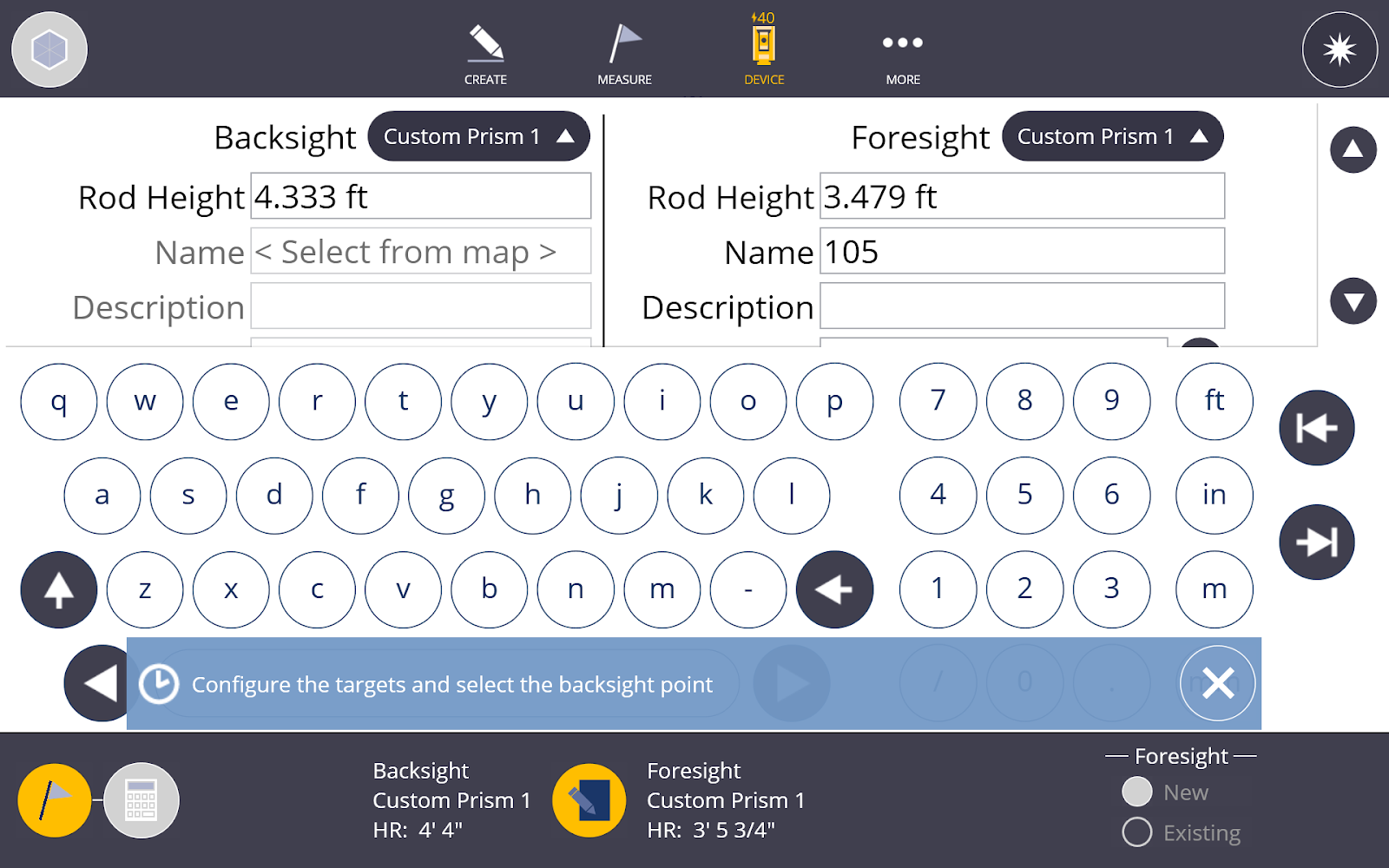
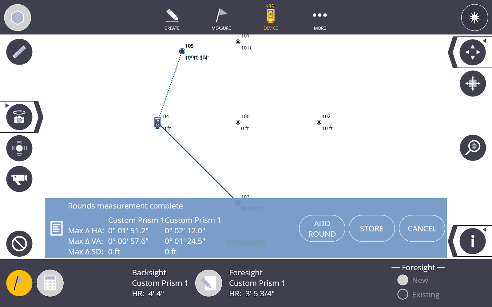
- To return to the map view, tap the Input Form icon again . Make sure the instrument location has been selected, then aim at the backsight point and tap Measure.
- Aim at the foresight location and tap Measure again.
- The instrument will then go through a series of Face 1, Face 2 and/or backsight/foresight measurements based upon the settings for rounds.
- Once the rounds measurements are complete, you can add a round to that set of measurements, or store the point.
-
Place the instrument over the foresight location, configure the targets using the Input Form, and place the actual prisms over the new backsight and foresight location.
-
Aim the instrument at the first location, which is now set to the backsight, and tap Measure.
-
Aim the instrument at the new foresight location and tap Measure.
-
Repeat this process for the remaining control points.
Traverse Calculations and Report
Calculation Definitions
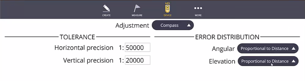
Adjustment
- Transit - In this adjustment method, it is assumed that directions are measured with higher precision than distances.
- Compass/Bowditch - In this adjustment method, it is assumed that distances and directions are measured with consistent precision.
Tolerance
- Horizontal Precision - Defines the lower limit for horizontal precision. Precision is the ratio of traverse length to horizontal misclosure.
- Vertical Precision - Defines the lower limit for vertical precision. Precision is the ratio of traverse length to vertical misclosure.
Error Distribution - Angular
-
Proportional to distance - adjustments are weighted more heavily for angles with shorter traverse lines than angles with longer traverse lines.
-
Equal proportions - angle adjustments are weighted equally regardless of the length of the traverse lines.
-
None - no angle adjustment is performed.
Error Distribution - Elevation
- Proportional to distance - adjustments are weighted more heavily for elevations with longer traverse lines than elevations with shorter traverse lines.
- Equal proportions - elevation adjustments are weighted equally regardless of the length of the traverse lines.
- None - no elevation adjustment is performed.
To Execute a Calculate and Save a Report
- Tap on the Calculation icon
 .
. - You can review the Traverse Result information.
- Summary
- Station information
- Distance adjustments (four difference sets of data can be review)
- Horizontal distances before adjustment
- Horizontal adjustments
- Vertical distances before adjustment
- Vertical adjustment
- Tap Accept and then tap Save, OR
- Tap the Input Form icon .
- Select the Adjustment Type (compass or transit).
- Input the horizontal and vertical precision.
Select the angular and elevation distribution (proportional to Distance, Equal Proportions or None)
The Traverse results are automatically recalculated.
Tap Accept and then tap Save.
You will have the option to open the report in a browser page. From here you can right click the report and save the .html report to a folder of your choosing. You can also right click and print the report as a PDF to a folder of your choosing.
- Tap the Input Form icon
