Antenna phase centers
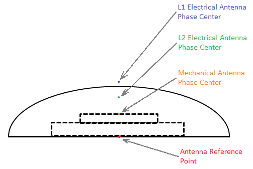
To understand Antenna Phase Centers (APC) and Antenna Reference Points (ARP), let’s begin with a diagram of an antenna:

The ARP is typically the point on the centerline of the antenna at the mounting surface. Above the ARP is the Mechanical Antenna Phase Center, this is the physical point on the surface of the antenna element where the Antenna Phase Center electronics reside. In some instances, the terminology Nominal Antenna Phase Center may also be used, particularly when this point is at an arbitrary location or a location meant to coincide with similar antennas. The actual Antenna Phase Centers for L1 and L2 frequencies are points (or clouds) in space, typically above the Mechanical Antenna Phase Center.
The GNSS receiver reduces all of the measurements at the L1 and L2 Antenna Phase Centers to the Mechanical Antenna Phase Center. The GNSS receiver outputs the coordinates for the Mechanical Antenna Phase Center in all of its output measurements. If you wish to further reduce the output coordinates (for example, reduce them to the ARP), you must do this reduction in your software applications, taking into account factors such as tilt of the antenna.
The GNSS receiver has an interface to setup the antenna type, antenna height, and antenna measurement method. The entered antenna height and antenna measurement method values are only applied when setting the GNSS receiver up as a base station, since the CMR or RTCM correction message outputs the coordinate of the base stations’ Mechanical Antenna Phase Center. However, typically only the coordinates of the ground station which the antenna is setup over are known. Entering the antenna height and antenna measurement method enables the software to calculate the height of the Mechanical Antenna Phase Center above the ground station.
When the Antenna Type field is set, the value of the RINEX Name field is automatically set, and vice-versa.
Setting the correct antenna type slightly improves the accuracy of the GNSS receiver, since the L1 and L2 Antenna Phase Center offsets are known and accounted for. In addition, the antenna model accounts for elevation-dependent biases of the antenna, so that the satellite tracking is corrected at various elevation angles.
If you want to know the offsets between the Antenna Reference Point and the various Antenna Phase Centers, Trimble recommends using the Configuration Toolbox software. In the Configuration Toolbox software, you can add the Antenna page and then select the antenna type:
If you select Bottom of antenna mount in the Method field, the True vertical height field shows the distance between the Antenna Reference Point and the Mechanical Antenna Phase Center.
If you want to understand the location of the L1 and L2 Antenna Phase Centers with respect to the Mechanical Antenna Phase Center, add the Antenna Model page and then select the antenna type. Click the L1 Model Calibration or L2 Model Calibration button to view the offsets and the elevation-dependent tracking biases:
These antenna calibrations are automatically used by the receiver when the correct antenna type is selected. You only need to add the Antenna Model page if you want to override the antenna models. Trimble recommends using the default antenna models.