Working with GNSS
The GNSS Status icon (e.g. ![]() , top left of the screen) shows you the status of the GNSS positions being received and their estimated accuracy.
, top left of the screen) shows you the status of the GNSS positions being received and their estimated accuracy.
High accuracy GNSS is required to accurately place a model in your surroundings using the measured and automatic placement functions.
NOTE –Your mobile device must be connected to an internet source with a 3G connection as a minimum, to receive corrections for high accuracy GNSS positioning. Without an internet connection, GNSS positioning will not be as accurate; Trimble Correction Hub connects you to the satellite-delivered RTX correction stream or to a local SBAS service.
The GNSS Status icon will show any of the following:
-
Red with no numbers. The system is starting for the first time, or is not running.
-
Red with numbers. The system has started tracking satellites. If the distance number is displayed the system is using the satellites to generate a position.
-
Yellow with numbers. The system is receiving differential corrections from a source and the position accuracy lies between 0.5 m
-
Green with numbers. The GNSS positioning accuracy has reached the threshold set for the accuracy limit (default 5 cm
The information shown on the GNSS Status icon is as follows:
-
number in the top right = number of satellites being tracked during start up or being used in the positioning solution.
-
distance value at the bottom = estimated horizontal accuracy of the GNSS position.
The default minimum GNSS value is 5 cm
To change the minimum value tap ![]() /
/ ![]() Tools/
Tools/ ![]() Configuration, then tap Advanced and set the GNSS Minimum High Accuracy.
Configuration, then tap Advanced and set the GNSS Minimum High Accuracy.
When using the Trimble RTX correction service, Trimble recommends that you change this threshold to 10 cm
NOTE –If you change this setting it is applied to all future work. If you are going to use the system later for tasks requiring greater accuracy, you must change the value back to a suitable level for the future work.
 Viewing detailed GNSS status information
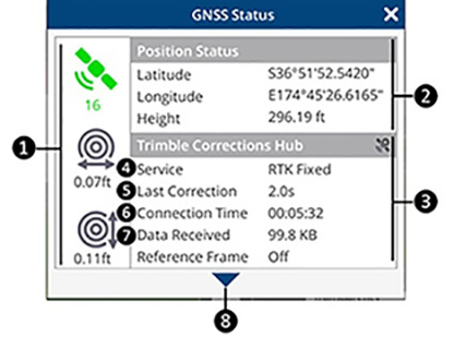
For detailed GNSS Status information tap the GNSS Status icon (e.g. ![]() , top left of the screen).
, top left of the screen).
|
1 |
Summary. Shows:
TIP – To change the distance units displayed in GNSS Status, go to Menu / Tools / Configuration / Units. |
||||||
|
2 |
Position Status. Provides the Global Coordinates of your position: Latitude, Longitude, and Height. |
||||||
|
3 |
Correction Source. This will display as Trimble Corrections Hub, NTRIP, or Direct depending on your GNSS Settings. |
||||||
|
4 |
|
||||||
|
|
When connected to a VRS Now or 3rd party network or an RTK network the positioning types will be:
When connected to the Trimble RTX service the positioning solutions will be:
If no VRS or RTX solution is available, possibly because of internet connectivity issues, and you are in an area with SBAS services (WAAS, EGNOS, QZSS etc.) then an SBAS positioning solution will be used. The Trimble Catalyst service monitors the accuracy that your system can achieve from the different signal types and automatically selects and outputs the solution type with best available accuracy. |
||||||
|
5 |
Last Correction. Time since last correction, in seconds. |
||||||
|
6 |
Connection Time: The time elapsed from the first connection to a corrections service by the SiteVision system. |
||||||
|
7 |
Data Received. Quantity of corrections data received since connection. |
||||||
|
8 |
Satellite Status. Tap The list shows the satellites that are being tracked and used in the position solution. The header bar shows the number of satellites being used and the number being tracked.
|
||||||
|
9 |
PRN. Identification Numbers of satellites in view. Each GNSS constellation is identified by a leading character.
|
||||||
|
10 |
SNR (dB). Signal-to-noise ratio (SNR) values for the satellites in view, expressed in decibels. NOTE –GPS satellites and QZSS satellites that broadcast the L2C code on the L2 frequency are shown with two SNR values. The first is for the L1 signal and the second is for the L2 signal. To get to an RTK Fixed solution for the most accurate positions you need to be tracking 4 or more satellites with L1 and L2 signals. |
||||||
|
11 |
Elevation. Elevation angles of satellites in view, expressed in degrees. |
||||||
|
12 |
Azimuth. Azimuth angles of satellites in view, expressed in degrees. |
||||||
|
13 |
Flags. Flags indicate if a particular satellite is being tracked (T) or is being used in the positioning solution (U). If the VRS network you are using does not provide corrections for all the constellations then you will see that the satellites are being tracked, but not used. |
||||||
 to expand the window to show the detailed status of the GNSS systems being used.
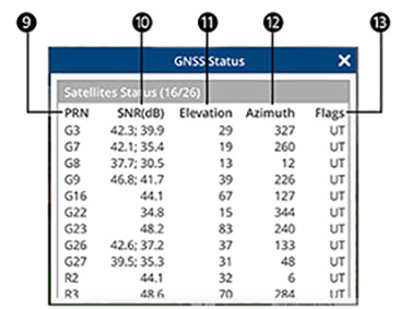 Managing GNSS
If the system does not initialize to green (<5 cm
-
Minimum Satellites Required. In general, at least six satellites are required to initialize and obtain a GNSS position. Of these at least 3 must be GPS satellites tracking both L1 and L2 signals.
The SiteVision system has the ability to track the following satellite constellations: GPS, GLONASS, QZSS, BeiDou, and Galileo.
To use these constellations the correction source needs to support these constellations. For more information about Trimble Corrections Hub go to catalyst.trimble.com.
-
Low latency correction. A low latency correction is when the time since the last correction is less than three or four seconds. If the latency is greater than five seconds the accuracy of the GNSS position will degrade with the increasing age of the corrections. If the age of corrections is high, check the reliability of your internet connection.
-
Correction Source Setup. Confirm that you have the correct credentials, such as:
-
Server URL
-
Server Port
-
Server Account Name
-
Server Account Password
-
-
Distance to your closest base station. The precision of GNSS depends on the distance between the base station and your location. It is desirable to keep the distance between them to less than 20 km
