Using Centerpoint RTX corrections
Siteworks v1.73 and later simplifies workflows for Trimble CenterPoint® RTX users, aligning them with those traditionally used for single-base RTK or network VRS GNSS corrections. Now, you can select a project's predefined published coordinate system, measure a new site calibration, or use an existing calibration all without needing to measure a datum offset, a step required in previous Siteworks versions. Siteworks v1.73 and later now automatically aligns CenterPoint RTX positions with your chosen site calibration or published coordinate system in real time through the use of the Trimble Time Dependent Transformation (TDT) coordinate engine.
This new TDT functionality is now automatically enabled when configuring a rover with either CenterPoint RTX (RTX corrections received over satellite) or RTX over internet. The software configures the rover to use a reference frame of ITRF2020 at the current epoch for the raw measurements. To set the reference frame of the receiver to a fixed value of ITRF2008 Epoch 2005.0, please contact your Trimble dealer to receive an option code to change Siteworks’ RTX behavior to match previous versions where measuring a datum shift is required.
The TDTs rely on information stored in a TimeDependentTransformationDatabase.xml file, which is located at C:\Program Files\Trimble Siteworks on Windows devices, and at Internal Storage/TrimbleSync/Trimble GeoData on Android devices. This XML file contains all the parameters for every type of TDT used by the Siteworks software. These and other necessary transformation files are now automatically installed into the Trimble GeoData folder during rover setup. If these files are deleted, they are replaced each time the rover receiver starts.
The TDT parameters used by a RTX rover during a survey are exported to a TDT.txt file in the output folder of the current work order. This file contains the specific parameters used in the transformation and can serve as a source for auditing the settings or any postprocessing calculations that may be undertaken outside of the Siteworks software.
It is possible to measure a site calibration using CenterPoint RTX with the TDTs. As in previous versions of the Siteworks software where a site calibration was measured with RTX, you cannot use an RTK rover on that site (that is, you cannot select Radio or Internet as correction options). The Siteworks software denotes a site calibration performed with CenterPoint RTX by adding a note into the DC file. To enable RTK corrections to be used on a site calibrated with CenterPoint RTX, a new site calibration using the RTK corrections must be performed over the same control points. On this RTK calibrated site, you can then use CenterPoint RTX without measuring a datum offset. Therefore, if the workflow allows and the site is expected to have both RTK and CenterPoint RTX rovers on it, it is recommended that the RTK site calibration is performed first.
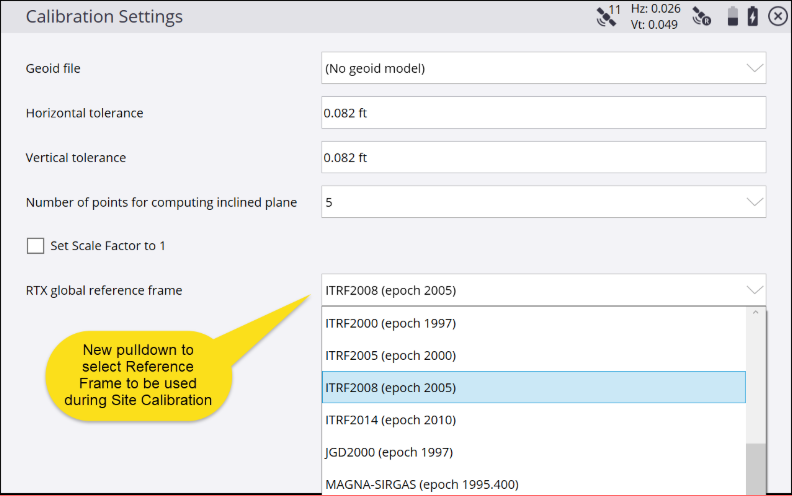
Siteworks will default to use a reference frame of ITRF2008 epoch of 2005.00 when measuring a Site calibration using CenterPoint RTX. It is possible to select the desired reference frame to be used during a CenterPoint RTX site calibration in the calibration settings, entered by tapping ![]() in the Project Calibration screen.
in the Project Calibration screen.
Additionally, site calibrations performed on top of a published coordinate system use the reference frame associated with that published coordinate system as defined in the Trimble Coordinate System Database. If a local base station is brought onto the site in the future or a different reference frame than ITRF2008(2005.0) is preferred, it is recommend to select a published coordinate system first that contains the reference frame of your choice. For example, select a US State Plane coordinate system to get a NAD83(2011) datum and then perform a site calibration. Starting with a published coordinate system should be done if you want to use a standard reference frame that is not ITRF2008(2005.0) in your project, even if using arbitrary control point coordinates that are not tied to a particular state plane system.
All latitude, longitude, and height (LLH) values stored in the SPJ of the work order and displayed in the info bar/panel will be ITRF 2020 at current epoch of measurement. There is currently no way to see the transformed LLH values of the project’s reference frame in Siteworks for measured points. The one exception to this is when performing a site calibration whereby LLH values stored in the .CAL file will be in the targeted transformed reference frame.
Tap the Correction Satellite icon in the Info Bar ![]() to open a screen that shows the project’s current Global Reference Frame being used in the project that the ITRF2020 current epoch LLHs are being transformed into, its fixed reference epoch, and any measured datum offset values. You can also clear any existing datum shifts by tapping Clear Datum Shift:
to open a screen that shows the project’s current Global Reference Frame being used in the project that the ITRF2020 current epoch LLHs are being transformed into, its fixed reference epoch, and any measured datum offset values. You can also clear any existing datum shifts by tapping Clear Datum Shift:
![]()
If you currently have a project where a base station was set up with an autonomous HERE position, then using a CenterPoint RTX rover with TDTs on the project may require the measurement of a datum shift to match the coordinates of the base station. This is because the base station’s reference HERE position was calculated autonomously, which is at a precision level lower than CenterPoint RTX. You can still measure a datum offset when using CenterPoint RTX as in previous versions of the software to get CenterPoint RTX to better match the coordinates of the project.
As technical background on RTX: coordinates measured in surveys using the Trimble CenterPoint RTX service are stored in the ITRF 2020 reference frame at the epoch of measurement. When you start an CenterPoint RTX survey, the Siteworks software uses the local displacement model, or if no local model is available for your location, the software selects a tectonic plate in the global tectonic plate model, to propagate the ITRF 2020 coordinate from the epoch of measurement to the Global reference epoch for the job. The software then applies a datum transformation to transform the ITRF 2020 coordinate into the Global reference datum for the job.
In Siteworks v1.72 and earlier, the receiver was set to propagate CenterPoint RTX coordinates in ITRF2008 at epoch 2005.0. A datum offset measurement was therefore required in the Siteworks software to transform these fixed ITRF2008(2005.0) ITRF reference frame coordinates to match the local coordinate system of the job.
The ITRF2020 reference frame is not commonly used on construction projects, where more standard reference frames like WGS-84 (used worldwide) or NAD83(2011) (used in North America) are used. This can result in position differences between the ITRF reference frame processed in the receiver and the fixed reference frames used on construction projects and for GNSS survey control. The new TDT functionality automatically transforms the ITRF2020 current epoch values from the GNSS receiver into the fixed reference frame of the project, thereby eliminating the need for a datum shift measurement to get the positions to match.
