Working with Coordinate Systems in GIS Connections
GIS data sources can have multiple feature types with coordinates expressed in one or more coordinate systems, which share the following characteristics:
- They are typically expressed using the standard format OGC WKT or EPSG ID codes. (The GIS providers in TBC use the OGC WKT format.)
- They may be projected (planar) or geographic (spherical).
- They may or may not include a vertical component.
- They include coordinate units.
- They typically do not include datum transformations.
Coordinate systems defined in TBC projects share these characteristics:
- They are expressed using coordinate system definitions from the Trimble coordinate system database.
- They always include datum transformation to and from the global reference datum.
- They often reference geoid files for vertical coordinate systems.
- Coordinate units are defined in the Project Settings.
The various formats used for coordinate system representation (for example, Trimble, OGC WKT, EPSG, and ESRI) use different names and may have slightly different parameters in definitions for the same coordinate systems. Therefore, the exact matching of GIS and TBC coordinate systems is not always possible. This is why, when establishing a GIS connection in TBC, you may be asked to select whether the TBC project coordinate system is equivalent to the GIS coordinate system and if coordinate transformation is required. Your selection, together with other coordinate system information, is stored as part of the GIS connection definition in the project file and used when writing features to GIS.
The write-to-GIS operation employs the following rules concerning coordinate systems:
- If the GIS coordinate system is LatLong, GlobalLL coordinates are used and no transformation is performed.
- If the GIS coordinate system is LatLong based on the same datum that is specified for the project coordinate system, LocalLL coordinates are used and no transformation is performed.
- If the GIS coordinate system is LatLong based on a different datum than is specified for the project coordinate system, the current project coordinate system datum is compared to the project coordinate system datum specified in the GIS connection definition. If it is different, a message dialog is displayed indicating that the project coordinate system has changed since the GIS connection was established and asking you to select a coordinate system based on the <datum name> datum. You will have to change the project coordinate system before writing features.
- If the connection definition specifies that that project and GIS coordinate systems match, the write operation proceeds with no warning. Grid coordinates from TBC are not transformed when written to GIS.
- If the connection definition specifies that that project and GIS coordinate systems do not match, the current project coordinate system is compared with the project coordinate system specified in the connection definition. If the current project coordinate systems are the same, the write operation proceeds with no warning and grid coordinates are transformed to the GIS coordinate system.
- If the current project coordinate system is not the same as the project coordinate system specified in the connection definition, the GIS Coordinate System Mapping dialog displays. Use it to specify whether to:
- Change the project coordinate system to match the GIS (file geodatabase) coordinate system and not transform grid coordinates
- Keep the project and GIS (file geodatabase) coordinate systems and transform the grid coordinates
- Consider the project and GIS coordinate (file geodatabase) systems to be the same and not transform coordinates
- Specify the elevation type coming from the GIS data source: Orthometric heights or Ellipsoidal heights.
Click OK after making your selection. The GIS connection properties are set to the new values as applicable and the write operation begins.
Note: The current project coordinate system and the coordinate system specified in the connection definition may be reported to be different when in fact they are not. This might be due, for example, to unexpected naming used to describe the datum. If you do not expect the coordinate systems to be different and/or want the project coordinates to be written as-is in the GIS database, choose option 3 above.
Note the following:
- TBC writes feature geometries in coordinate units from GIS (WKT).
- TBC does not try to match vertical components of the TBC and GIS coordinate systems. Instead, it always stores the feature elevation (height above geoid if a geoid is selected, or height above ellipsoid if not) as a Z coordinate (if GIS can store Z coordinates). It is your responsibility to select a geoid in TBC that matches the one used in GIS.
- TBC and various third-party GIS software (for example, ESRI software) do not all support the same projection algorithms and/or they use different variants of those projections. At this time, any Trimble coordinate systems using the following projections are not compatible with GIS software. They will always be reported as different in the GIS connection, and they cannot be used to upload data to a Shapefile or file geodatabase.
- Plane
- Mercator
- Krovak
- United Kingdom National Grid
- Denmark Hungarian EOV
- RD Stereographic
- Grid Projection
- Snake Grid Projection
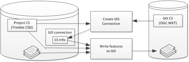
The following diagram illustrates how coordinate systems factor into the the GIS connect and write process:
Note: TBC and various third-party GIS software (for example, ESRI software) do not all support the same projection algorithms and/or they use different variants of those projections. At this time, any Trimble coordinate system using projection Plane, Mercator, Krovak, United Kingdom National Grid, Denmark Hungarian EOV, RD Stereographic, Grid Projection or Snake Grid Projection, are not compatible with GIS software. They will be always reported as different in GIS connection. And they will not be usable for any data export as Shapefile or file geodatabase
