Create Points at Station Offsets
The Create Points at Station Offsets command enables you to quickly and easily create multiple points along a user-defined baseline by first specifying the station and offset for each point you want to create and then running the command to create them all at once automatically. You specify the point ID and feature code for each of the points, which are organized into collections in the Project Explorer.
Prerequisites:
See the Subscription Plans page. For a license matrix by command, see the License page in the TBC Community. Also see View and manage licensed features.
To create points by station offset:
- Select Create at Station Offsets in Survey > COGO to display the Create Points at Station Offsets command pane.
- Enter a Name for the collection of new offset points to be created.
This name will be used in the Project Explorer.
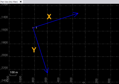
- To define the start of the temporary baseline to be used for offsets, click in the Start point field and enter a point ID or coordinate. Or, select a point or coordinate in the Plan View. Optionally, change the Station and/or Offset you want to assign to the Start point.
- To define the end of the baseline to be used for offsets, click in the Endpoint field and enter a point ID or coordinate. Or, select a point or coordinate in the Plan View. Optionally, change the Station and/or Offset you want to assign to the End point.
The distance between the two selected points is displayed in the Distance SE field.
Two blue arrow display indicating the X and Y axis to be used for positioning the new points.
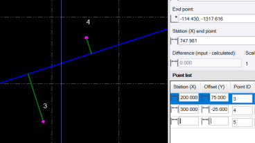
If you change the calculated Station (X) start point and/or Station (X) end point value, a delta value may display in the Difference (input - calculated) field.
- If a delta value displays in the Difference (input - calculated) field, select the appropriate Error adjustment option to specify if and how errors are distributed amongst the new points.
- No Adjustment - This is the default.
- Along the line - Adjustments are made to stations only (not offsets) based on the calculated adjustment scale factor, which is displayed in the Scale field.
- Along the line and the offset - Adjustments are made to both stations and offsets based on the calculated adjustment scale factor, which is displayed in the Scale field.
- In the Point list, do the following:
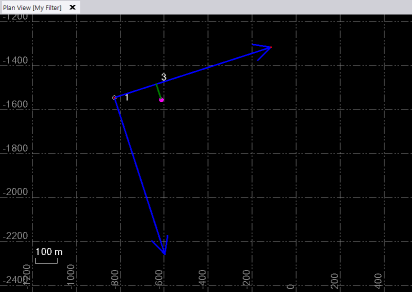
- In the Station (X) field, enter a station along the baseline at which you want to create a new offset point.
- In the Offset (Y) field, enter the distance from the baseline you want to offset the new point. A positive distance value places it to the right of the baseline. A negative distance value places it to the left.
The new temporary point is displayed in the Plan View. with a green offset line connecting it to the baseline.
- Optionally, change the Point ID.
- Optionally, enter a Feature Code to assign to the new point, or select to create a new one to assign.
- Repeat to create additional offset points.
Tip: For rapid data entry, use the Tab key when entering data in the Points list.
In the following example, a second offset point was create to the left of the baseline using a negative Offset (Y) distance value
- When you are done, click Ok to save the new points in the project.
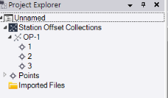
The temporary baseline and green offset lines ares deleted and the new points are displayed in the Plan View.
In addition, a new Station Offset Collections parent node is displayed in the Project Explorer with the new collection of offset points nested beneath it.
If you want to edit the collection after saving it, right-click the collection node in the Project Explorer and select Edit to open the collection in the Create Points at Station Offsets command pane, where you can make changes as necessary.
