Run a Points to Cloud Report
 The Points to Cloud Report command compares points to a point cloud region or scan to determine the nearest scan point to the selected point and provides a comparison between the derived point pairs. This tool compares measured ground check points with computed point clouds from drone surveys and slam scans.
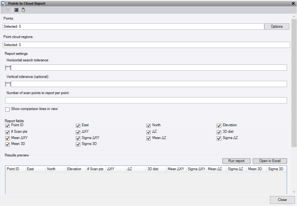
- Click in the Points field, then in a graphic view select the points to compare to the cloud. Click Options for additional selection options.
- Select the Point cloud regions to use for the comparison. You can select multiple point cloud regions.
- Enter a Horizontal search tolerance distance to scan the point cloud and find scan points that fall in this radius.
- Optionally, enter a Vertical tolerance. Leave this field blank to use the same value as the horizontal.
- Enter the Number of scan points to report around each selected point.
- Check Show comparison lines in view to see the vectors between the point and the scan points.
- Click Run report to calculate results and show in the preview table.
- Click Open in Excel to report all the selected fields into an Excel sheet.
- Click Close to close the command pane.
Note: This feature does not work on vertical walls.
Report fields:
|
Option |
Description |
|
Point ID |
Comparison point ID |
|
East |
Easting coordinate |
|
North |
Northing coordinate |
|
Elevation |
Elevation |
|
# Scan pts |
Number of scan points that are found within the search tolerance |
|
Delta XY |
Horizontal distance delta between the point and the scan point |
|
Delta Z |
Vertical distance delta between the point and the scan point |
|
3D dist |
Slope distance between the point and the scan point |
|
Mean delta XY |
Mean horizontal distance of the scan points reported |
|
Sigma delta XY |
Standard deviation of the horizontal distance of the scan points reported |
|
Mean delta Z |
Mean vertical distance of the scan points reported |
|
Sigma delta Z |
Standard deviation of the vertical distance of the scan points reported |
|
Mean 3D |
Mean slope distance of the scan points reported |
|
Sigma 3D |
Standard deviation of the slope distance of the scan points reported |
