Process Event Data
When performing a kinematic or static GNSS survey, the user can use a receiver’s external trigger channel to record the time of one or more events during the survey. These are referred to as "event markers". Each event marker represents the precise time for which the user wants to determine a location (for example, when an aerial photograph is taken). Because event markers do not typically coincide with receiver measurement times, the position for the event marker must be calculated by interpolation during baseline processing in the software.
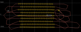
When a data file containing event data is imported into the software and baselines are processed, the software uses the event data to calculate positions for the event markers, which are displayed as diamond symbols in a trajectory in the Plan View. Following is an example of Plan View showing event markers in "Trace" display mode.
Note: If you import event data from a static GNSS survey, you must force the data to be processed as continuous data using the Force Continuous command.
Before processing event markers, be sure to set baseline processing settings appropriately for the type of event marker interpolation you want performed.
For instruction on exporting event data, see Export Event Data.
