Scanning and point clouds
View, manipulate, and extract information from terrestrial, mobile, and aerial point cloud data.
-
Colorize, register, georeference, and adjust Trimble SX-series, Trimble TX-series, Trimble X-series and third-party scan data.
-
Scale scan and point cloud data to survey data in an integrated project environment.
-
Compare as-built reference point cloud regions to BIM objects, tunnel design meshes, surfaces, or other point cloud regions to create heat maps.
-
Extract point, line, and cross-section features using user-defined planes with automatic and semi-automatic feature extraction tools.
-
Filter point cloud data and prepare ground regions for surface modeling with Advanced Filtering and the Dynamic cell size option, which adapts sampling cell size to changes in terrain, preserving features from being removed during filtering.
-
Integrated 3D Deep Learning technology improves results of point cloud classification regions and feature extraction options for terrestrial and aerial data, including domain-specific classifiers for railway.
-
Customize point cloud classification and train AI models.
-
Automate the stockpile extraction and volume computation process from point clouds with just a few clicks.
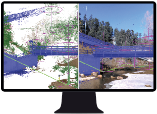
Extract features from scans and point cloud data.
Resources
YouTube playlist
Tutorials
Trimble Learn courses
