Release notes 6.2
This document contains summary information on new features, latest product information, updates as well as installation and upgrade procedures for Trimble® 4D Control™ version 6.2.
Introduction
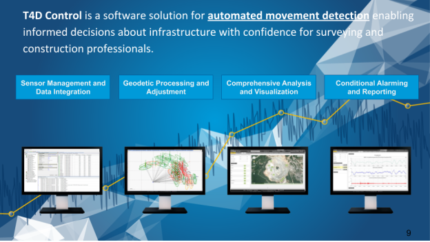
Trimble 4D Control provides automated movement analysis and visualization so you can easily manage your monitoring sites. It is the core of a monitoring project because it controls the measurements, manages and analyzes the data and alerts, delivering the data you need to make timely decisions.
Trimble 4D Control is a scalable software solution for monitoring applications. Options range from simple manual monitoring operations to complete automated 24/7 real-time monitoring systems. The software manages, processes and stores data from optical total stations, GNSS receivers, and geotechnical sensors.
Preliminary Remark
If the Settop M1 is used to connect a total station for usage with Trimble 4D Control, make sure to update the Settop M1 firmware to version 4.2 or later before upgrading to version 6.2 of Trimble 4D Control.
Sensor Management and Data Integration
Expansion of Geotechnical Support
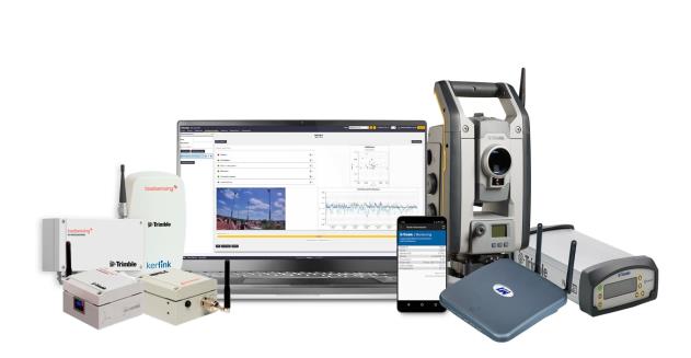
Trimble Monitoring just announced the availability of a new portfolio titled Geotechnical. The Trimble Geotechnical portfolio includes:
-
Wireless geotechnical sensors – Tiltmeter and laser-tilt sensors, providing tilt and distance measurement readings directly to the gateway.
-
Wireless data loggers – Vibrating wire, and digital and analog data loggers, supporting connections with a wide range of geotechnical digital and analog sensors communicating information to the gateway
-
Gateway – Rugged Long Range (LoRA) radio and 4G gateway, enabling communication with the wireless geotechnical sensors and data loggers to connect the project site with the office through a cellular or local network
-
Configuration software - A mobile application for data logger configuration and a web user interface for network and device management
-
Accessories – Installation accessories for a variety of mounting and configuration environments
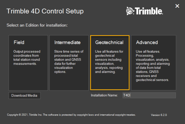
New Geotechnical Software Edition
The core of Trimble Monitoring is the Trimble 4D Control software. In addition to the current three editions of Trimble 4D Control, a new edition titled Trimble 4D Control Geotechnical is now available. The new edition streamlines the installation, deployment, and workflow for automated monitoring users utilizing geotechnical-only setups where no geodetic processing is required (total stations and GNSS). All capabilities of Trimble 4D Control for charting, analysis, alarming, and project management are available.
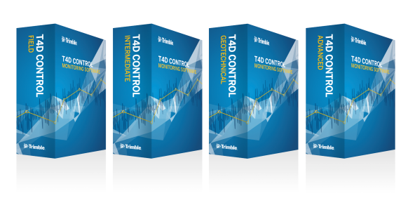

The new Trimble 4D Control Geotechnical edition can be easily installed through the Trimble 4D Control installer which also allows an easy upgrade to the Trimble 4D Control Advanced software edition if needed in case of increasing project demands.
Trimble Geotechnical Gateway Support
Trimble 4D Control now supports the Trimble Geotechnical Gateway which is available for selection at the project and sensor management of Trimble 4D Control.
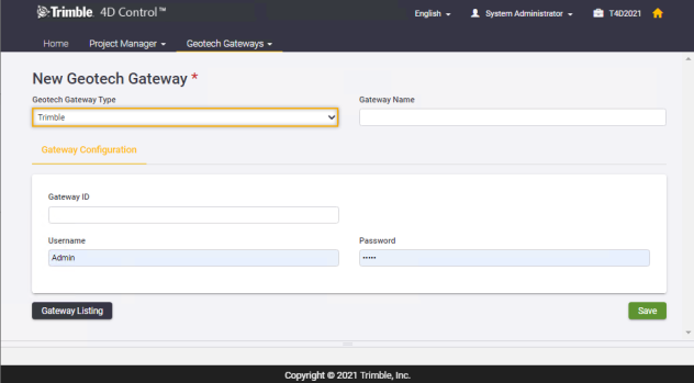
The Trimble Geotechnical Gateway gathers data from all wireless sensors and data loggers deployed on site and transfers the data via internet connection (cellular or ethernet) to Trimble 4D Control.
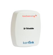
For more information on the gateway, see this datasheet.
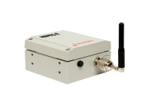
Trimble Geotechnical Sensor Support
Trimble 4D Control supports streaming data from both the Trimble laser-tiltmeter sensor and the Trimble triaxial tiltmeter sensor through a Trimble geotechnical gateway connection.
Laser-Tiltmeter
The laser-tiltmeter wireless sensor is a 2-in-1 laser distance sensor and tiltmeter where the laser measures the relative distance between pairs of reference points. The tiltmeter provides measurements of changes from the vertical level (vertical reference angle), and is used to monitor inclinations, movements and differential settlements of slopes and infrastructure.
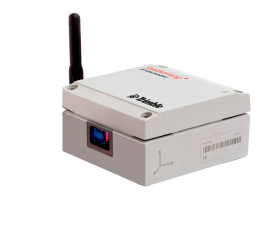
For more information on the wireless laser-tiltmeter see this datasheet: laser-tilt.
Triaxial Tiltmeter
The triaxial tiltmeter sensor, Tilt90-x, has an extremely accurate tri-axis sensor with an extended range of up to 90 degrees. This provides additional flexibility and multiple orientation options during installation. Same as the laser-tiltmeter, the robust triaxial tiltmeter is capable of transmitting data via long-range radio to the Trimble geotechnical gateway and due to its low power consumption the triaxial tiltmeter can operate for several years unattended relying solely on the replaceable internal batteries.
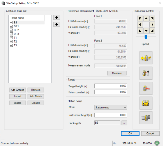
New Site Setup Dialog (Settop M1 connections)
Complete Total Station control through the Settop M1
The site setup dialog of the Trimble 4D Control Data Collector no longer requires a direct connection to the total station in any case, if the instrument is connected through the Settop M1. Adding a new point, performing a reference measurement, resetting the reference circle and/or modifying the station setup mode can now be performed through Trimble 4D Control while the Settop M1 keeps controlling the instrument. The corresponding “connect” button at the site setup dialog is no longer needed; please see further below.
Removing the need to temporarily take over total station control for specific site setup related tasks is a significant time saver in particular for dynamic monitoring environments where the monitoring point list must be regularly updated.
New Video Dialog
Trimble 4D Control now supports video streams of total stations that are connected through the Settop M1 in a new video extension of the site setup dialog. The site setup dialog is often used to add new targets and modify the list of points measured in a round. If the connected total station has an integrated camera, having the option to open its video stream in the software, provides best possible assistance for these workflows. The location and condition of targets can easily be checked remotely even before adding them to the monitoring setup and it also allows verifying if there is line of sight in case a target cannot not be measured.
The video stream inside Trimble 4D Control offers a lot of new features and is also very consistent with the video support of our Monitoring field software Trimble Access Monitoring:
-
Crosshair - The crosshair on the video stream indicates the point the instrument is targeting.
-
Point overlay - Targets are displayed on the video stream that allows for a better orientation and understanding where the instrument is pointing to.
-
Click navigation - The instrument can be moved by clicking onto the video dialog.
-
90°/180° rotation buttons - Allows for faster navigation.
-
Brightness control - Depending on the environment it may be required to adjust the brightness setting of the video stream.
-
Zoom buttons - On the upper left of the video dialog a couple of zoom related buttons allow for great flexibility. Next to a zoom in and zoom out button, Trimble 4D Control also offers a maximum zoom in/out button.
-
Zoom scale - A zoom level indicator provides orientation on the current zoom level in relation to the minimum and maximum zooming capabilities of the connected instrument.
-
Automatic flip of video on second face


Enhanced Look and Feel
Several enhancements have been added to the site setup dialog that help to easier understand the current total station status, improves some workflows and provides further information on the reference measurements.
-
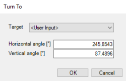
Turn To button - This function allows you to either select an existing target but also to enter an arbitrary angle value the instrument can be turned to automatically.
-
Compensator Status - The site setup dialog streams the tilt values of the total station and indicates its status by showing a colored icon on the bottom right corner.
-
Reference measurement information - The information on the date and the time of the currently used reference measurement is shown on top.
-
Measure Control - The measure button moved slightly up and is now part of the reference measurement section.
-
Display of measurement mode - A new field provides information about the measure mode used per target (“AutoLock”, “FineLock”, “Long Range FineLock”, “Direct Reflex”).
Comprehensive Analysis and Visualization
Alignment Based Monitoring
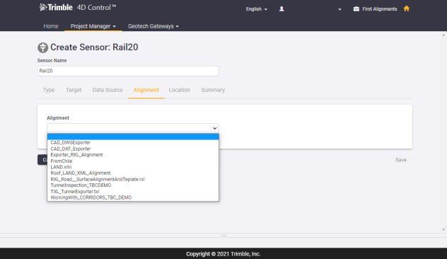
Many monitoring applications like tunnels, roads, railways, bridges and dams, require any potential movement to be expressed with regard to the geometry of the object instead of relating them to the axis of the set coordinate system. For example, the displacement for a monitoring point located on a railway is reported relative to the direction of the rail instead of in coordinate terms making interpretation and analysis of the data more meaningful.
Instead of coordinate system related values, delta Northing (dN), delta Easting (dE) and delta Height (dH), the displacements shall be available as delta Station (dStation), delta Offset (dOffset) and delta Vertical (dVertical) values. These values are associated with and refer to an alignment definition that mathematically defines the geometry of a monitoring object. “dStation” represents a displacement along the alignment, whereas “dOffset” (horizontally) are values perpendicular to the alignment.
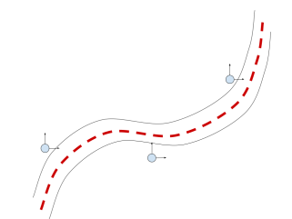
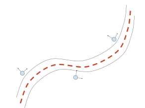
Northing and Easting Station and Offset
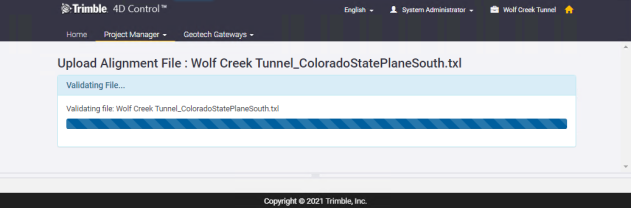
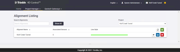
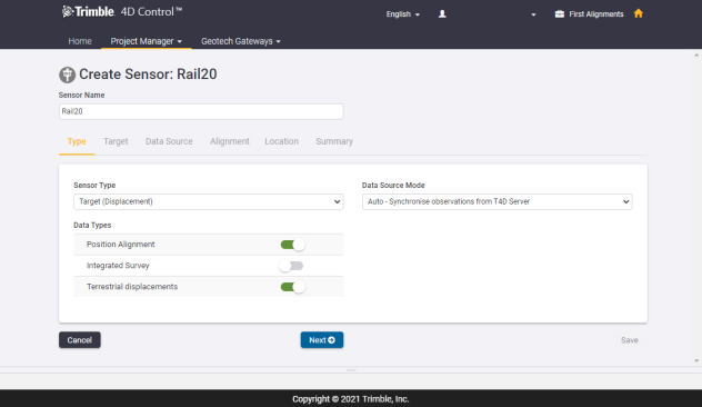
The workflow in Trimble 4D Control is very smooth and looks as follows:
1. Upload of the alignment file representing the monitoring object
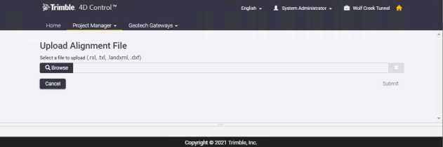
2. Association of positional sensors with an alignment
The alignment tab becomes visible once the data type “Position Alignment” is enabled together with one additional data type when adding new positional sensors.
3. Visualize data, create analysis and alarms, generate reports etc.
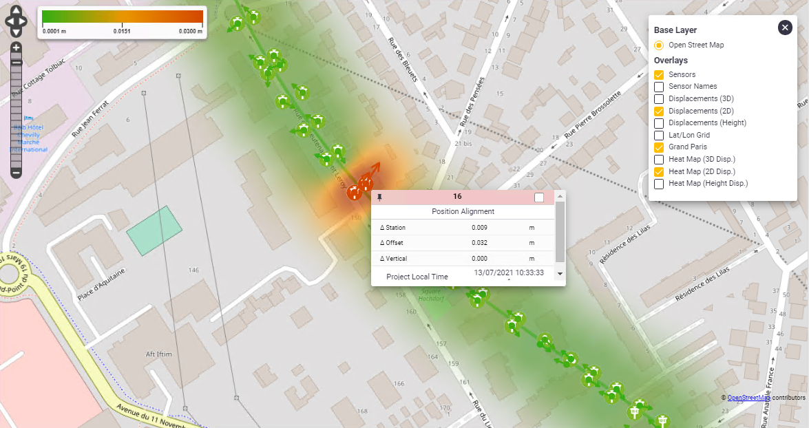
The 2D geometry of an alignment can be visualized next to the sensors on the Maps page of Trimble 4D Control Web.
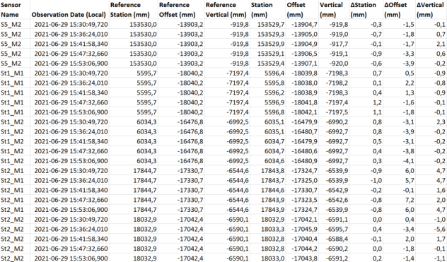
The Positional Sensor Readings Report supports Station, Offset and Vertical data.
Italian language support in Trimble 4D Control Web
The project and sensor management of Trimble 4D Control Web is now also available in Italian language. With this version of Trimble 4D Control a user can choose between English, Spanish, German, French, Russian, Bulgarian, Japanese, Chinese and now Italian.
Conditional Alarming and Reporting
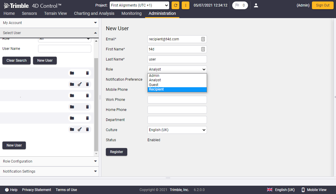
New user role 'Recipient'
Trimble 4D Control now has an option that enables a system operator to send reports to selected recipients without the need to give them access to Trimble 4D Control at the same time. A user of Trimble 4D Web that is assigned with the new user role “Recipient Only” will be able to receive reports but will not receive any other system notifications. This simplifies access to monitoring reports for non-T4D users.
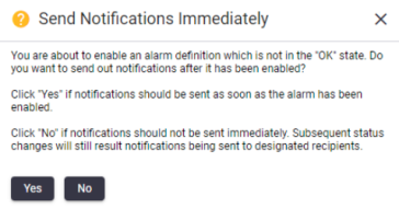
Extended Logic when enabling Alarm Definitions
Trimble 4D Control now provides a user with an option to suppress notifications from being sent out in order to avoid (redundant) communication to stakeholders. A message automatically pops up when enabling the alarm definition if the last time it was evaluated, the severity level was either attention, warning or alarm.
Resolved Issues
-
The Measure Round command of the Data Collector module can now be used again in combination with the Settop M1.
-
Same applies to the Settop M1 diagnostics feature that is now available for the Data Collector module.
-
An issue related to the round scheduler where the round measurements did not start at the correct time under certain circumstances has been addressed and resolved.
-
Conversion to Data Collector file based is now working successfully even if there are spaces in the module configuration name.
-
A fix has been applied that addresses an issue when installing Trimble 4D Control to an Azure SQL Managed Instance.
-
Improved reliability of data synchronization from Senceive to Trimble 4D Control. After this improvement a re-baselining of data in Senceive will no longer cause data gaps when performing an historic data import.
-
The Length2D data type can now be used as input for calculation sensors too. This is relevant to e.g. Senceive Tiltbeam sensors.
-
A warning message has been added that informs users when the browser blocks http mjpeg webcams on https hosted Trimble 4D Web instances.
-
A dialog scaling problem of the data collector module has been resolved.
-
Fixed Issues with Positional Sensor Readings Report:
-
Value Per Day did not yield any results for velocities
-
Trend 3D values were always blank
-
-
An issue with a mixed up point list when using the 'arrow up' in the site setup is solved.
System Requirements
Supported Operating Systems
Trimble 4D Control version 6.2 supports the following operating systems:
-
Windows Server 2019 (October 2018)
-
Windows Server 2016 (September 2016)
-
Windows 10
Supported SQL Servers
Trimble 4D Control version 6.2 supports the following Microsoft SQL servers:
-
SQL Server 2019
-
SQL Server 2017
-
Azure SQL Server
With regard to Trimble 4D Control Intermediate and Trimble 4D Control Advanced Trimble highly recommends using a full Microsoft SQL Edition that is not subject to limits in memory capacity. This is in particular critical for monitoring systems with many sensors and processing engines.
Supported Browsers
Trimble 4D Control Web is tested on the latest versions of Google Chrome, Mozilla Firefox and Microsoft Edge. Microsoft Internet Explorer is being retired by Microsoft and is no longer supported by Trimble 4D Control Web.
Deployment and Installation
Download of Trimble 4D Control
The installer of Trimble 4D Control version 6.2 is available for download from the Trimble Monitoring website (monitoring.trimble.com). Some additional information on the installer:
-
It is a single installer for all available software editions of Trimble 4D Control (Field, Intermediate, Geotechnical and Advanced).
-
Depending on the software edition that has been selected, only the required installation files are downloaded.
-
The Trimble 4D Control Field and Trimble 4D Control Geotechnical software editions include an automatic download and installation of Microsoft SQL Express 2019.
-
The installer offers a “Download Media” option for an offline installation on a different server that has no internet access. In this case the installer downloads the entire set of installation files for all software editions.
New Installation
To install Trimble 4D Control version 6.2, please perform the following steps:
-
Run the Trimble 4D Control installer executable.
-
Select the Trimble 4D Control software edition you have a license for.
-
Wait for the installation files to be downloaded.
-
Follow the instructions of the installation wizard.
Make sure you have your Microsoft SQL database administrator credentials available if you install the Intermediate or the Advanced Edition of Trimble 4D Control.
Upgrade of an Existing Installation
If the Settop M1 is used to connect a total station for usage with Trimble 4D Control, make sure to update the Settop M1 firmware version to version 4.2 or later before upgrading to version 6.2 of Trimble 4D Control.
To update the software from a previous version to version 6.2, please perform the following steps:
-
Ensure that the existing installation of Trimble 4D Control is running on version 6.1. If not, please update to version 6.1 first.
-
Back up all Trimble 4D Control configuration files (*.tde) using the “ConfigurationImportExport” tool that is available from the Trimble 4D Control Server installation directory.
-
Create a database backup (*.bak) using the Microsoft SQL Server Management Studio
-
Run the installation of Trimble 4D Control version 6.2. The installer automatically detects and uninstalls version 6.1, before proceeding with the installation of version 6.2.
For more information, please contact monsol_support@trimble.com.
Release notice
This is the July 2021 release (Revision A) of the Trimble 4D Control Software Release Notes. It applies to version 6.2 of the software.
