Release notes 6.5
This document contains summary information on new features, latest product information, updates as well as installation and upgrade procedures for Trimble® 4D Control™ version 6.5.
Introduction
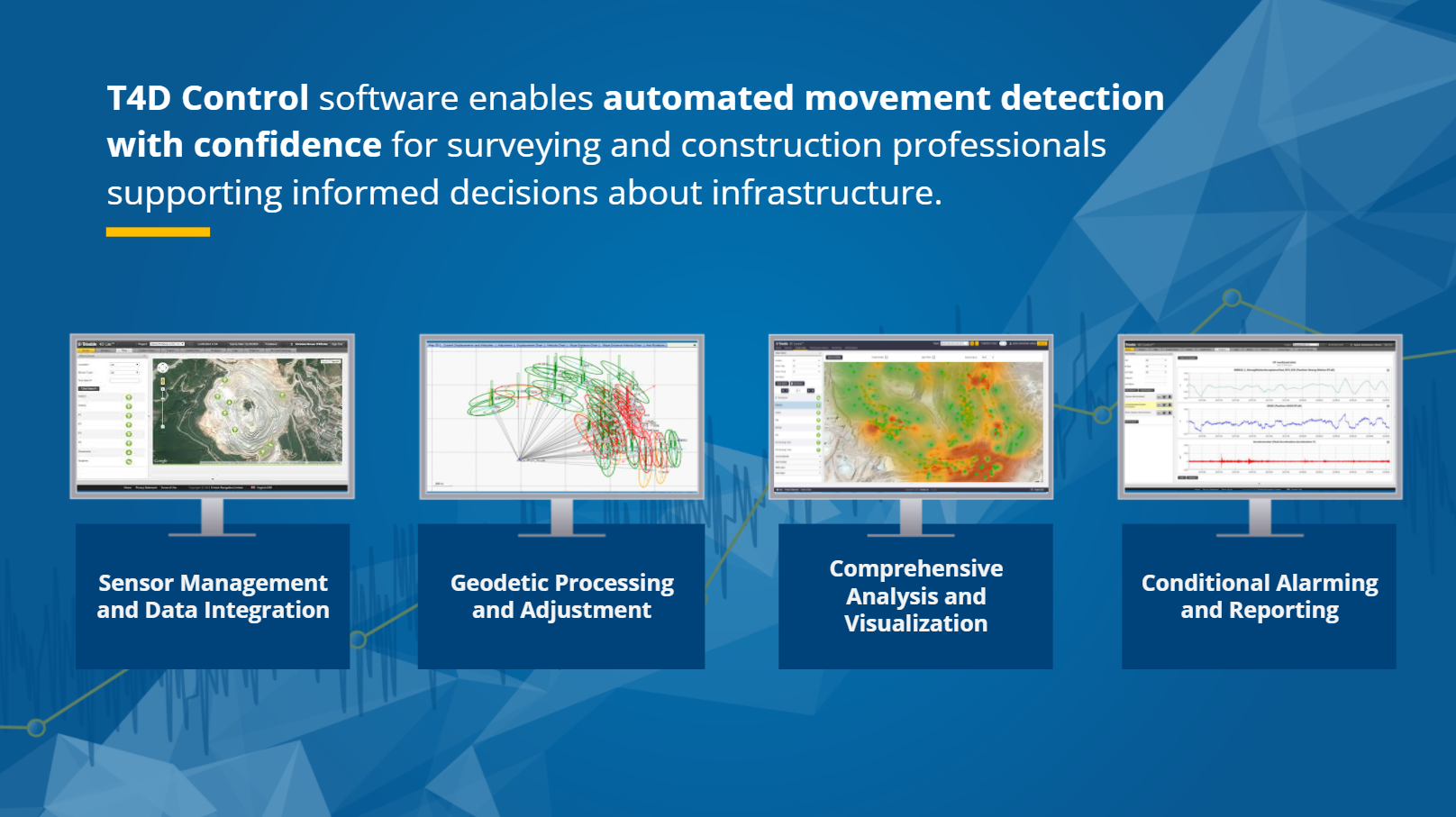
Trimble 4D Control (T4D) enables automated movement detection with confidence for surveying and construction professionals supporting informed decisions about infrastructure. T4D provides benefits in four core areas:
-
Sensor management and data integration, providing support for GNSS, total station, geotechnical, vibration and environmental sensors.
-
Geodetic processing and adjustment to deliver the most accurate and reliable information from the combination of sensors through network adjustment and integrated processing engines.
-
Analysis and visualization through a set of comprehensive visualization, charting and analysis tools providing real-time updates.
-
Alarming and reporting leveraging conditional and project-specific alarming and defined user roles, providing up-to-date notification to key stakeholders.
For further support information, visit the Product Information webpage and Support & Downloads sections online.
Rail track monitoring module expansion addresses a wide range of standards and specifications
Understanding the behavior of the track's geometry is crucial for ensuring the safety of railway traffic, whether in the areas where construction is happening, regions prone to natural hazards, or aging infrastructure awaiting renewal. With the new Rail module introduced in December 2022, customers have the capability to monitor critical rail track geometry parameters, contributing to the maintenance of high rail safety standards.
The new T4D 6.5 version comes with the new and enhanced Rail module features that offer more flexibility and deliverables, addressing user feedback and diligently refining the module to meet customer expectations.
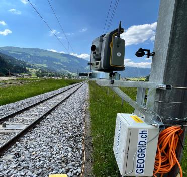
Total station monitoring rail geometry
So far, the supported method included the AMTS and installed prisms, necessitating the use of collected as-built survey data within the so-called *.track file. Leveraging the as-built track geometry data, T4D Rail automatically performs precise calculations of rail parameters (see Figure 2) with every round measurement.
The track measurement bar, in combination with the Trimble Access Track Gauge Survey app, continues to stand out as a fast and cost-effective solution for conducting precise as-built surveys. For more details on the Trimble Access Track Gauge Survey app please refer to the trimble-railway website.
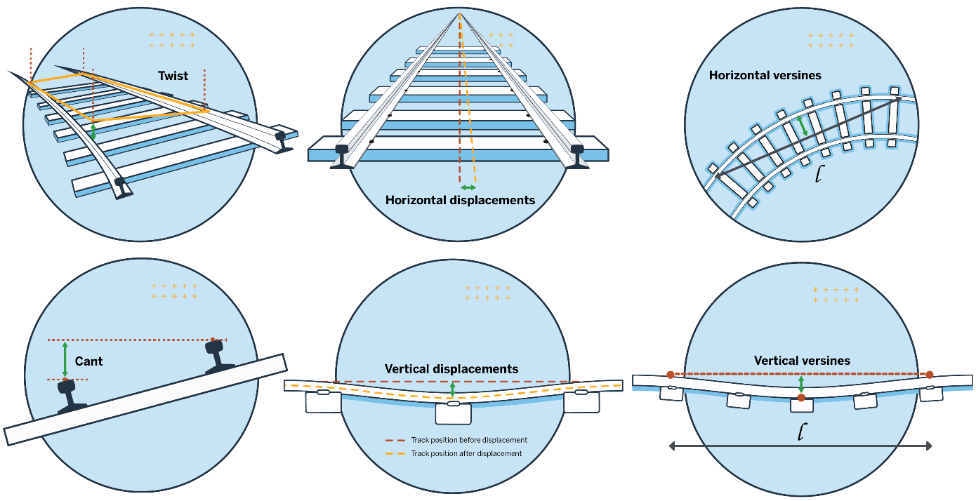
Rail geometry parameters
AMTS Rail Monitoring Without As-Built
The new version provides the ability to monitor the rail track using the AMTS system without as-built data. This is very valuable in scenarios where the time window for setting up the automated monitoring system and collecting as-built data is limited or in projects where relative cant and twist values, next to displacements and versines, are sufficient.
After entering the chainage information and interval, cant basis information and selecting the first two sensors (prisms), T4D will automatically sort all the sensors along the monitored track, therefore saving time and making the process less error-prone.
These methods offer users increased flexibility for rail monitoring. Since not every project is the same, having the flexibility to select the most suitable approach is highly valuable. With just one click in the software, the chosen approach can be defined, preserving the core value - simplicity.
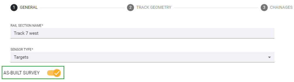
Option to select if the As-built survey is available
Rail Monitoring with Tiltmeters
T4D Rail now supports using tiltmeters for rail monitoring. Tiltmeters offer an excellent solution for applications where a relative change of cant and twist is sufficient. Depending on the project requirements, this approach can be used as a pre-warning system or a complete solution. The desired approach can be selected with a simple click during the first step when creating the Rail Monitoring Section.
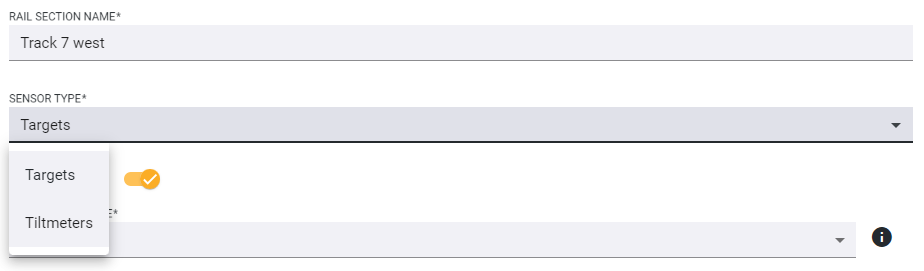
Selecting the sensor type
During the process of adding the sensors in T4D, it is important to take care of proper, meaningful naming patterns since T4D will use the sensor name to sort the sensors across the track. After inputting the necessary information, T4D Rail automatically organizes tiltmeters along the track, thereby saving time and reducing the likelihood of errors in the entire process.
Tiltmeters monitoring railway track
New Parameter Calculation
Left & Right Rail
In response to valuable customer feedback highlighting the diverse customer requirements and project specifications that differ across regions and projects, this new version now includes support for calculating displacements and versines for both rails next to the track centerline, offering more flexibility to tailor the deliverables to customer needs.
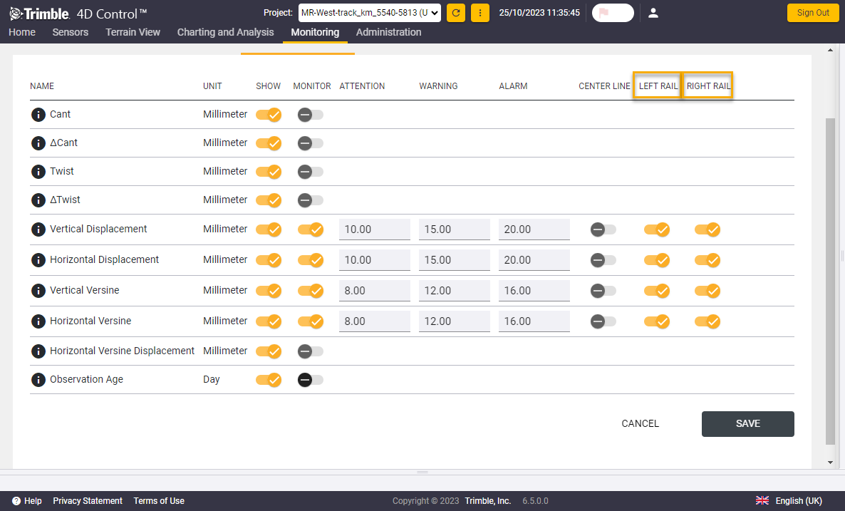
Selecting left and right rail as optional parameters to be monitored
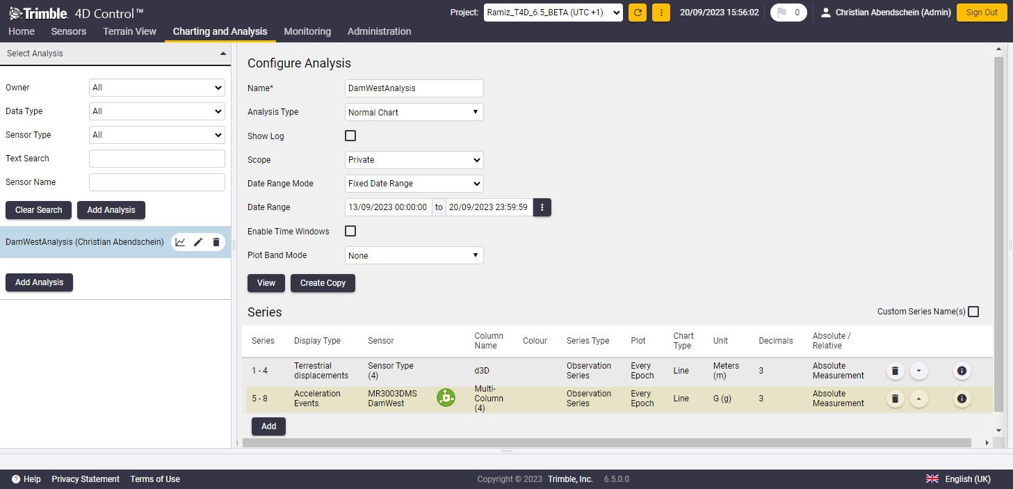
Multi-Series Charting Capability
This updated version has promoted the creation of insightful visual representations for calculated data to a whole new level. When simultaneously monitoring both rails or even all three choices: centerline, left, and right rail, the user can conveniently display all the relevant data in the charts, both across chainages and time. This new visualization capability empowers the user to make well-informed decisions based on that visualized data.
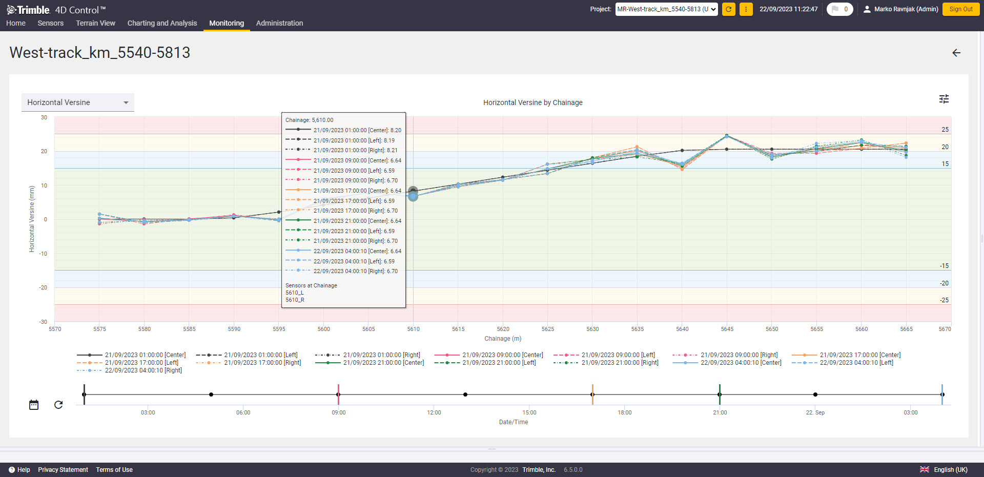
Multiple Series Chart by Chainage
Detailed Report
Creating a single report that fulfills all project requirements remains challenging, but we have addressed this by introducing the option to export data into a Detailed report. This Detailed report contains all the supplementary information necessary for generating specific rail monitoring reports. In addition to the existing parameter values and other valuable data, the Detailed report includes coordinate deltas from both the left and right rails, along with the centerline. It also provides comprehensive coordinate information for both rails and the track centerline for every measured epoch at each chainage.
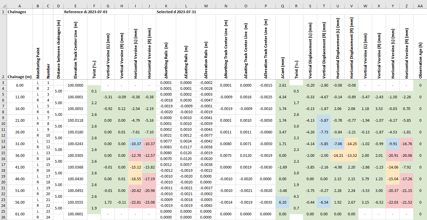
Detailed report
In the new version, height parameters are calculated using the Top of the rail point, while positional parameters rely on rail Running Edge coordinates.
Empowering flexibility with new options
Selecting the Height Reference Rail
Selecting a specific rail as the height reference (see Figure 9) ensures that the cant value has the correct sign when the chosen rail is lower or higher than the opposite rail, depending on the desired result. As cant is predominantly represented as a positive value, it was initially visualized only as a positive value in version 6.4 of the software. With this current version, however, we have expanded its visualization capabilities to include negative values, thus aligning with a broader range of country requirements.
Twist Output
Another option in the new version of the Rail module enhancing flexibility is supporting additional units regarding Twist values. The expression of rail twist varies across different countries, and addressing this variability by supporting various units and visualization approaches was the challenge successfully resolved in this version. In the previous version, the supported units were ‰ and %. However, starting from this version, the Rail module can express Twist in Units of length (mm, m, in, ft, and us-ft) and as a gradient (see Figure 9). When expressed as a gradient, Twist is represented as a ratio as 1 in x, indicating 1 unit of change in cant over x units of chainage.
1 in 300 is the cut-off value for charting purposes which means twist values less severe than 1 in 300 are excluded from charts and T4D states "No action required" in such cases.
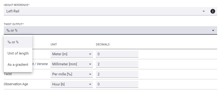
Height Reference and Twist Output selection windows
Even though we have introduced additional settings and options as described above, we have kept the main benefit of the module, which is simplicity. Once the Rail section has been created, the settings will be saved and suggested next time the user creates a new Rail monitoring section. These settings can be modified, but if some are consistent, it will save time during creation.
Horizontal Versine Displacement and Horizontal Versine
In the initial version, we calculated the horizontal versine using horizontal displacements. However, in this updated version, we have introduced the "true" horizontal versine calculation. As a result, the previous method of calculating the horizontal versine based on displacements has been renamed to "Horizontal Versine Displacement". Meanwhile, the "Horizontal Versine" is a newly introduced parameter that relies on the track's horizontal geometry.
Exceeded Observation Age Alarm Threshold Stops Parameter Calculation
In a rail environment, measurements of the prism may be missed due to factors like passing trains. In such cases, the software relies on the most recent available measurement. The Observation Age parameter comes into play to keep track of how old that measurement is. In this version, we have implemented a feature that stops parameter calculation once the Observation age reaches its Alarm threshold. This safeguard ensures that outdated data is not used for parameter calculations.
Enhancements
Rail Section Status
-
Added search window, timestamp information, and refresh button
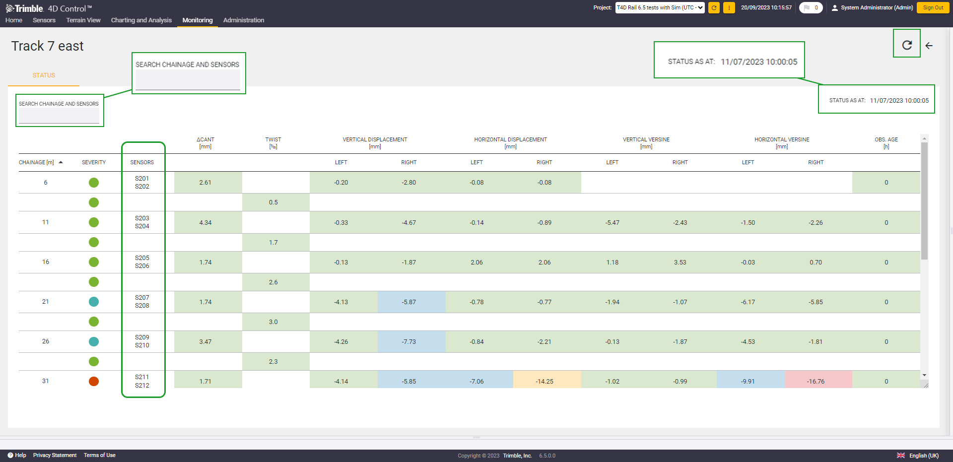
Information in the Rail Section Status window
-
Sensor information is now shown on the Rail Section Status page (see Figure 10), which allows an easy understanding of which sensors are positioned at which chainage.
-
Frozen header at Rail Section Status page to keep the overview when analyzing data.
-
Rail Section Status is now being displayed in the T4D Web Project Status window.
Visualization
-
Added point number information in the chart tooltip (see Figure 11)
-
Epochs and chainages are now being sorted
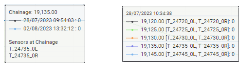
Sensor information in the tooltips - Charts by Chainage and Charts over Time
Acceleration sensor support for event-based monitoring of ground motion
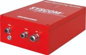
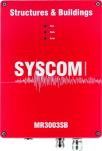
MR3003DMS and MR3003SB acceleration sensors
Syscom Instruments is a leading supplier of vibration and seismic monitoring equipment for civil engineering, strong motion and safety industries. As of this version, T4D complements its vibration sensor offering by supporting Syscom Instrument's acceleration sensors MR3003DMS (dam monitoring system) and MR3003SB (structures and buildings).
Acceleration sensors are widely used by earthquake and structural engineers in areas with seismic or volcanic activities. Such activities generally cause the most energetic vibrations, also referred to as strong motions, and can damage structures, leading to a collapse in the most critical cases.
In order to avoid such incidents and to ensure continued building operability for critical infrastructure like dams, historical and high-rise buildings or hospitals, permanent structural monitoring and risk assessment based on strong motion sensor data is a must and very often mandatory.
The acceleration sensors from Syscom Instruments provide the data required to be able to assess a structure's integrity and to put in place relevant, responsive actions. Their low frequencies acquisition, starting from static 0 Hz, allows these sensors to record every natural frequency of large (concrete) structures with also very high sensitivity for low peak ground acceleration amplitudes.
While the MR30003DMS sensor is a dedicated instrumentation for equipping dams (star network architecture support, fiber optics, over-voltage protection etc.), the MR3003SB sensor is designed to be deployed to buildings and other structures.
The key characteristics of the sensors are listed in the following:
-
Integrated with MEMS (Micro Electro Mechanical System) triaxial acceleration sensors (+-4g range)
-
All-in-one rugged IP67 housing
-
Seismically tested and certified devices
-
Fiber optics for long distances on dams
-
LAN networkable devices with trigger logic
-
Self-diagnostic features
-
Connectivity through star network (MR3003DMS) and daisy chain network architecture (MR3003SB)
-
Seismic trigger based relay output
-
Internal battery
-
Time synchronization using GPS (optional)
MR3003DMS and MR3003SB strong motion sensors
For further information on the newly supported strong motion sensors, please refer to the Syscom Instruments website.
Acceleration sensors vs. velocity sensors
|
Support introduced in… |
T4D v6.3 |
T4D v6.5*NEW |
|
Sensor type |
Velocity |
Acceleration |
|
Supported sensors |
|
|
|
Main applications |
|
|
|
Purpose |
|
|
|
Alarm regulations |
|
n/a |
|
Frequency |
|
0hz (static) to ~500Hz
|
|
Calibration |
Required every 2 years |
No calibration due to integrated MEMS sensor type, very stable over time |
|
Project duration |
Time limited (construction project duration typically between 6 months - 2 years) |
Permanent (10-15 years for a dam for example), lifetime of instrumentation |
|
Users |
|
|
Sensor connectivity and configuration prerequisites
Required sensor configuration settings
With regard to the strong motion sensor configuration, some important information must be taken into account so sensors can successfully operate in combination with T4D:
-
The time must be set to UTC
-
Background data upload must be enabled.
-
Background acceleration data must contain peak acceleration measurements
-
Background (BMR) and Event files (XMR) must be written in ASCII format
SFTP server connection
Strong motion acceleration sensors are connected to T4D through an SFTP connection. Both the MR3003DMS and MR3003SB have a built-in SFTP client for that purpose that must be configured so data is continuously pushed to the appropriate SFTP server.
Users can leverage the built-in Settop M1 monitoring controller SFTP server to ensure smooth data integration between vibration sensors and T4D. The connection can be established through the public internet by also benefiting from the ISTConnect cloud service, but the entire system can also be configured to run inside a local area network (LAN). LAN connections can provide a solution for environments where restrictive IT policies are in place.
Data analysis and visualization
Correlation of movement patterns of different sensor types
T4D allows combining the newly supported acceleration sensors with geodetic and geotechnical sensors. Having all sensor data in one common software platform for data analysis not only reduces overall corporate software and training costs but more importantly, allows for a complete view of asset risk, leading to more informed decision making.
Analysis options with other sensor data
With the support of trigger-based events and continuous background recording modes, both strong motion sensors offer efficient vibration solutions in earthquake environments.
Event data
Event data are short recordings triggered by specified trigger thresholds on the acceleration sensor. Typically, their duration is no more than two minutes, but it depends on pre-event and post-event settings on the sensor. Acceleration event recordings are immediately provided to T4D.
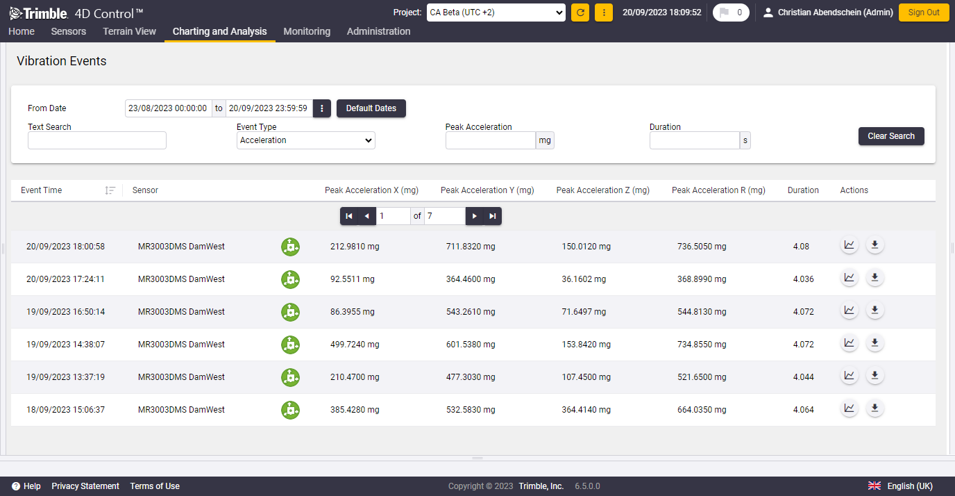
Tabular overview of strong motion events
Strong motion acceleration event data visualization and analysis is supported by the vibration events section at T4D Web. Recorded events of all vibration sensors are listed in a tabular view and allow for easy navigation. Users interested in strong motion events choose acceleration as the event type.
The tabular overview provides information on peak acceleration for each sensor axis and event duration information for each acceleration event.
Vibration events can be filtered by additional parameters (e.g. peak acceleration, event duration, etc.) and thus allow for an easy identification of particular vibration events and for comparing peak acceleration values originating from different events.
Event raw file download option
Vibration event raw files containing acceleration data can also be downloaded from here and allows the recorded data to be used for structural health analysis and subsequent data processing beyond T4D.
Event waveforms
Vibration event charts can be viewed in T4D and are easily accessible from here as well. The visualized waveforms per strong motion event and per acceleration sensor axis (x,y,z) allow for more detailed event analysis and assessment.
Tabular overview of acc events
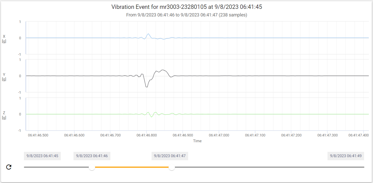
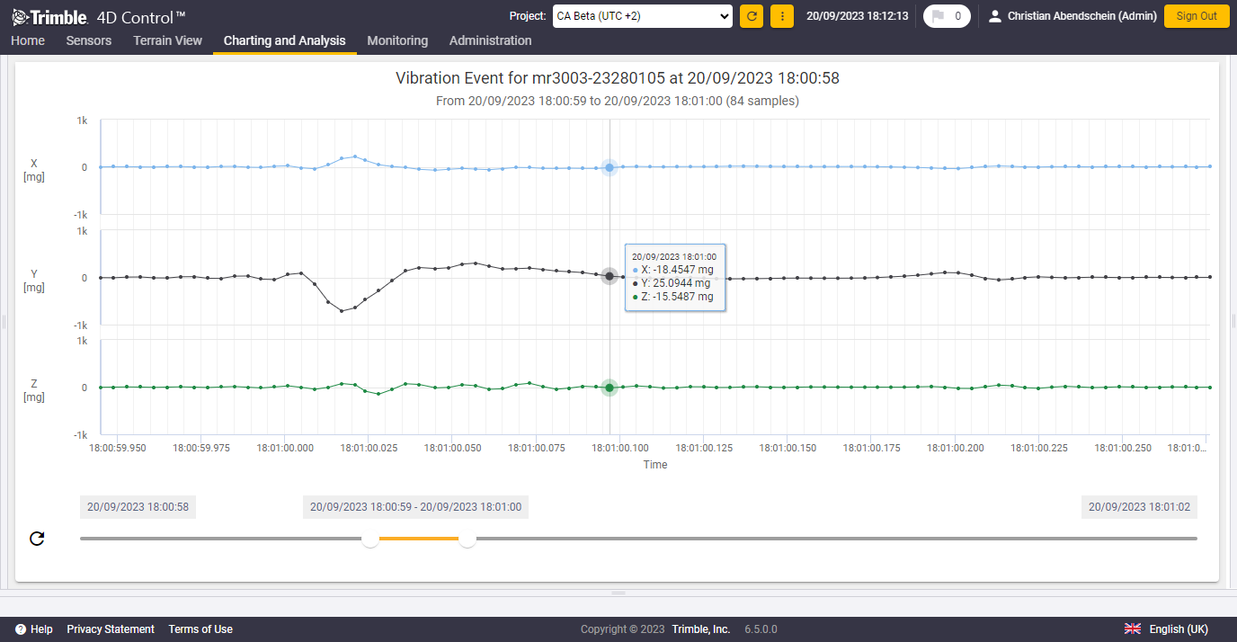
Examples of acceleration event waveforms
Background data
Strong motion devices typically record data in a configured low interval (e.g., every 60 seconds), which is also referred to as background data. There are different modes available based on which background files contain peak acceleration only, peak acceleration and vector sum values or peak acceleration, vector sum values and dominant frequencies.
Continuous visualization
T4D supports the visualization of time series of background acceleration measurements per sensor and per sensor axis. Peak acceleration of background data is visualized at a constant time interval, depending on the configuration on the strong motion sensor hardware itself.
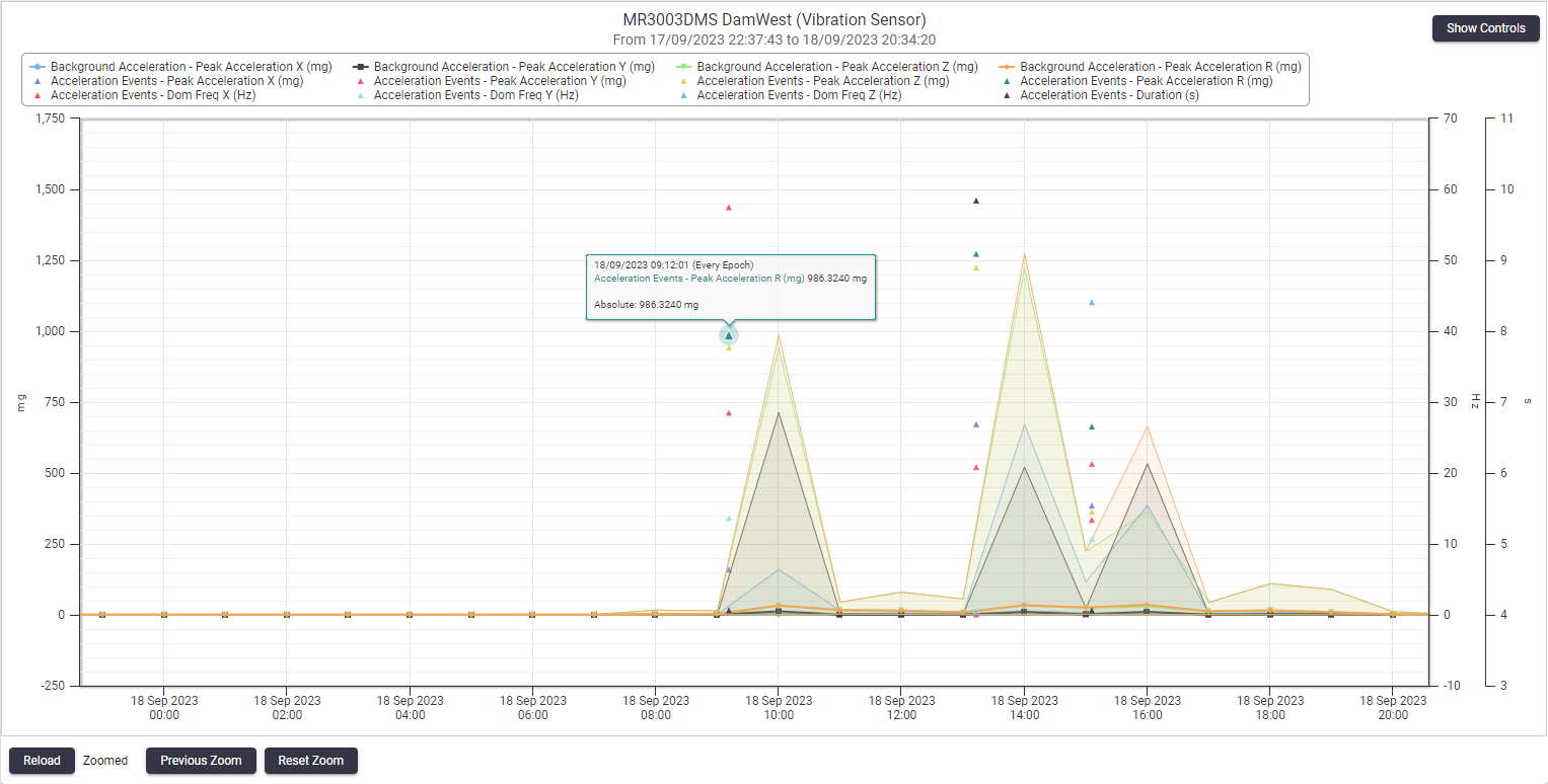 Background acceleration data time series
If the configured trigger thresholds were exceeded in the selected date range, peak acceleration values of the included events are also visualized. T4D also allows drilling down into the acceleration events from here to further analyze their waveform.
The peak acceleration measurement during the event is typically orders of magnitude larger than the background peak acceleration measurements. It is recommended to visualize the Peak Acceleration R (vsum) value for event data to easier differentiate between background data and event data.
Alarming on acceleration data
Key alarming capabilities of T4D
The ability to evaluate measured data and take prompt actions following an earthquake ensures safety and sustainability of structures. T4D addresses this need by providing the following feature rich powerful alarming capabilities.
-
Various alarm conditions form one alarm definition. Each alarm condition is an expression whose thresholds get evaluated against observation values from the specified sensors that can be of different types. This way geodetic observations can be combined with acceleration data and only if all defined alarm criteria are met a notification is sent by T4D.
-
T4D offers different severity levels such as attention, warning and alarm for increased granularity. Due to lower thresholds a warning message for example may not necessarily lead to a building evacuation but it informs stakeholders to pay attention.
-
A certain group of recipients can be associated with each alarm definition. Only these configured recipients will be notified whenever the alarm definition triggers an event.
-
Alarms in T4D can be configured in such a way that events have to be acknowledged by duly authorized and configured users. Alarm events that are not acknowledged within the configured time period will be escalated to a second and subsequently a third set of recipients.
Event alarming
T4D supports alarming on the following strong motion sensor data (that can also be combined with alarm conditions for other sensors):
-
Peak acceleration for each sensor axis
-
Vector sum (Peak Acceleration R)
-
Dominant frequencies for each sensor axis
-
Event duration
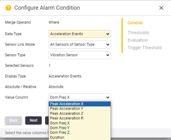
Acceleration data that can be alarmed on
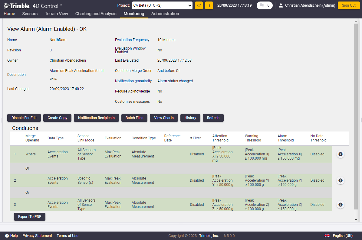
Example of an enabled alarm definition for acceleration data
No data alarm
Depending on the sensor configuration acceleration background data contains peak acceleration and dominant frequencies for every axis and is typically received every x minutes or every x hours by T4D. To ensure a continued data stream, T4D provides a no data alarm feature that is recommended to be used in conjunction with the acceleration background data. T4D raises an alarm if it did not receive any data for the specified period of time and sends a notification to the specified recipients.
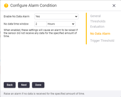
No data alarm configuration
Significant IT security enhancements to adhere to customer's corporate IT policies
IT security has always been a core value for Trimble. The T4D Code base is regularly reviewed from a cyber security perspective and libraries used are continuously checked against databases that list known vulnerabilities. Due to regular updates T4D always complies with the highest security requirements.
The new version further increases software security by providing an option to authorize and authenticate T4D users from an active directory and allow database connections using secure Windows authentication.
Both new features allow greater control over user access to the T4D system and better adherence to IT policies.
Authorize and authenticate T4D users from an active directory
Active directory and the advantages for T4D users
Active Directory (AD) is a database and a set of services that connect users with corporate network resources. The database (or directory) typically contains information about the entire corporate environment, including what users and computers there are and who is allowed to do what. For example, the database might list a certain number of user accounts with details like each person's job title, phone number and password. And it also records their permissions.
Active Directory services control much of the activity that goes on in such a corporate IT environment. In particular, they make sure each person is who they claim to be (authentication), usually by checking the entered credentials, and allow them to access only the data and resources they are allowed to use (authorization) - via Active Directory group membership.
As a consequence of the Active Directory support, T4D users leverage from the following benefits:
-
Use corporate credentials to access T4D Web - Users are not required anymore to use application specific usernames and passwords but can use their corporate credentials
-
No password hashes stored in the T4D database - Using Active Directory authentication removes the need for T4D to store password hashes in its database.
-
Central corporate user management - T4D users can be managed via Active Directory group membership and they do not need to be added through T4D Web
-
Automatic sync between active directory and T4D - New active directory users associated with a T4D related group automatically gain access to T4D Web as users with the associated T4D role.
New active directory configuration page at T4D Web
Under the administrative security settings page a new section called “Active Directory Configuration” is now available. This area allows T4D administrators to enable Active Directory authentication.
Provided T4D has access to the active directory domain controller and the information on the active directory group(s) is available, the required configuration steps are straightforward and as follows:
-
Enable active directory
-
Specify active directory domain to use
-
Map T4D roles with active directory groups
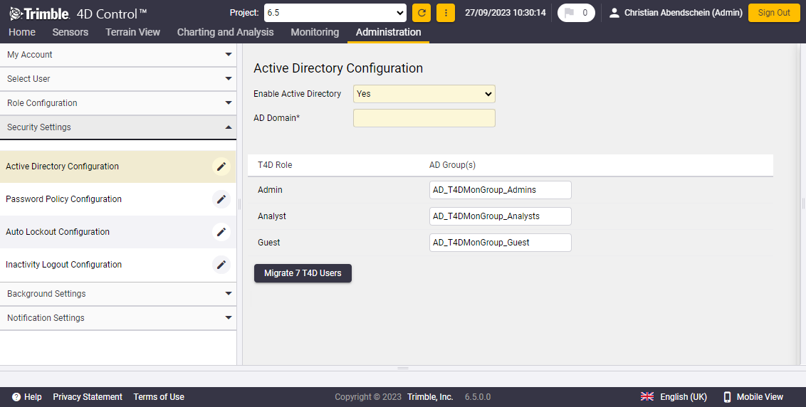
Active directory configuration page
Once the active directory is successfully configured, active directory users show the authentication type “Active Directory” and can log in to T4D using the active directory user name.
Usernames that are used to log in to T4D Web must be identical with the ones in the active directory and are not necessarily email addresses like with the in-built T4D authorization and authentication scheme.
The following user configuration settings are no longer available for active directory users as they are managed by active directory in such cases:
-
Change of project and roles (authorization)
-
Disable user
-
Reset password
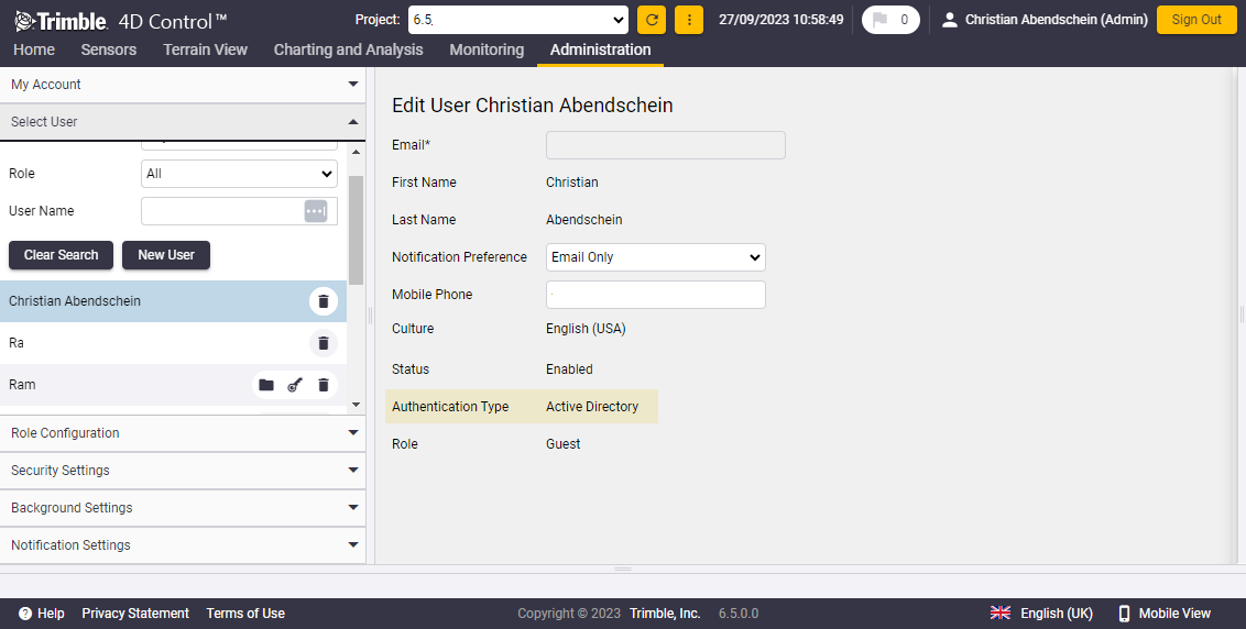
Active directory user edit page
Migrate T4D users to active directory
T4D allows a mix of users that authenticate against the built-in T4D authentication scheme and users that authenticate against active directory. To seamlessly migrate all pre-existing T4D users to Active Directory authentication, T4D provides an intuitive migration feature. The only prerequisite for this is that pre-existing T4D user email addresses must match the email addresses used in Active Directory (see image above: Active directory configuration page).
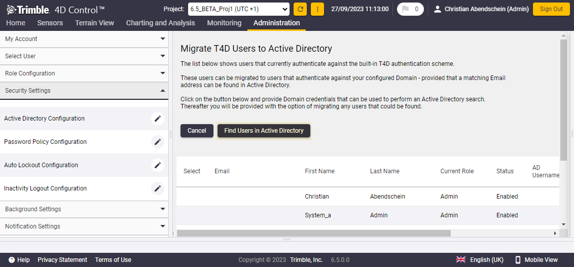
Migrate T4D users to active directory
If you choose to migrate all users to authenticate and authorize against Active Directory (including all administrative accounts), be aware that you are dependent on the availability of the Active Directory domain controller to log in to T4D Web.
Windows Authentication to SQL Server from T4D
Depending on corporate IT policies, customers may or may not be allowed to use SQL server authentication due to IT security reasons. In such cases the preferred authentication mechanism for accessing the T4D databases is to use Windows authentication instead.
By default a new login using SQL server authentication is created at the time of installing SQL server which is a prerequisite for the installation of T4D. The SQL server authentication mode is independent of Windows user accounts. Username and password are created and stored in the SQL master database in hashed form.
SQL Server also supports Windows Authentication, under this mechanism Windows confirms user (and process) identities for authentication purposes and SQL Server does not store password hashes in the master DB. The connection using Windows authentication is regarded as a trusted or integrated connection and is therefore less vulnerable to attacks by hackers.
As of this version, T4D enables users to change from default SQL server authentication to Windows authentication by applying a few configuration steps after the installation of T4D. A detailed instruction guide outlines what needs to be configured to make this happen.
For more information, please contact monsol_support@trimble.com.
More Improvements
Login screen background image
T4D Web now provides the flexibility to customize the login screen background image. Administrators can access the system administrator settings to replace the default background with an image of their choice. This feature not only enhances personalization but also provides a clear visual indicator to users about the system they are accessing on the login screen.
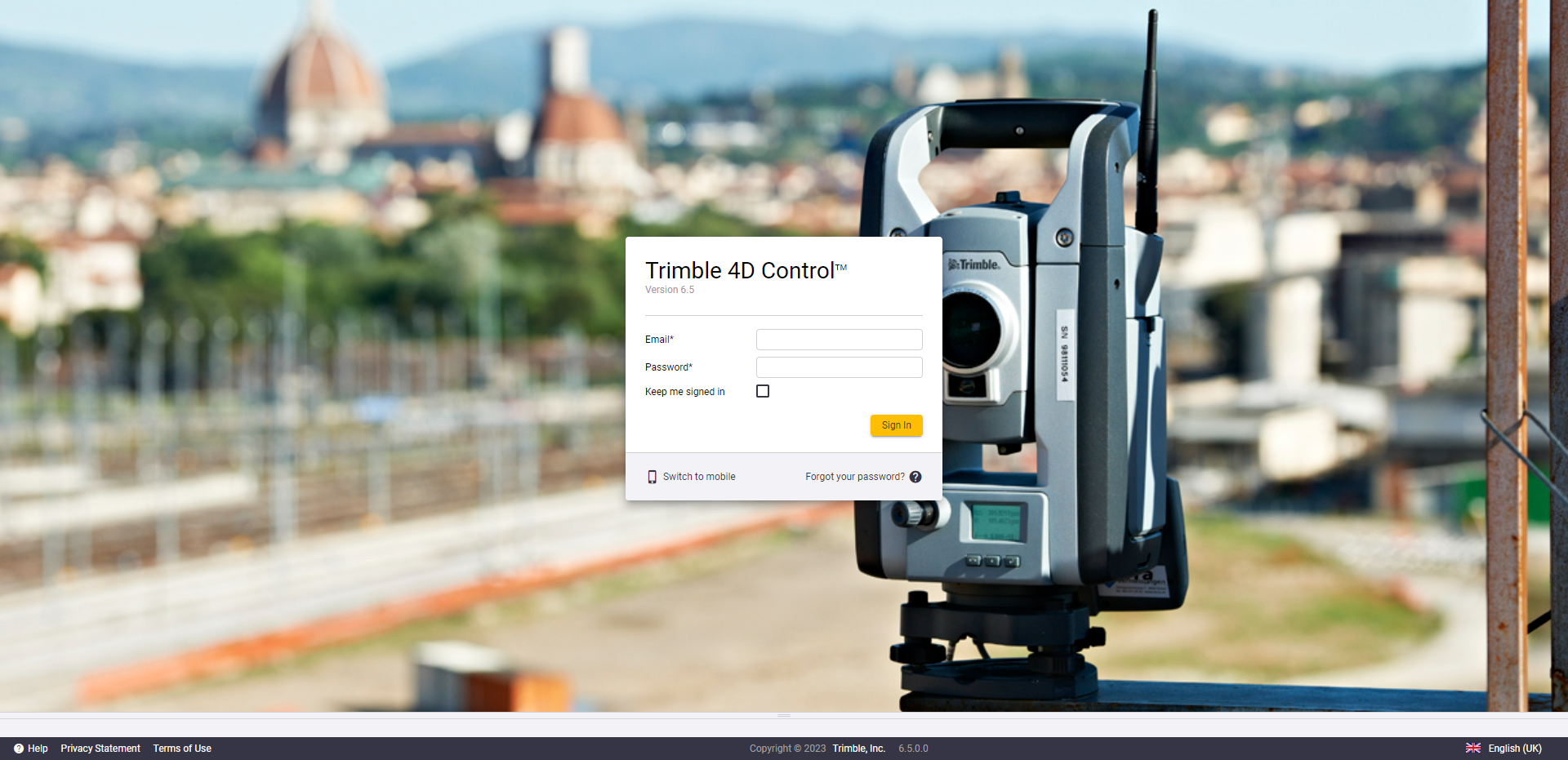
Example of customized background login image
Reports as .docx file format to allow for edits
Another customization improvement is the ability to generate reports as a .docx file instead of a .pdf only. This setting can be specified at the time of creating a report schedule, or an existing schedule can be modified. This new feature allows for further customization to a report, and allows operators to optionally modify content so it matches the requirements before sending it to stakeholders.
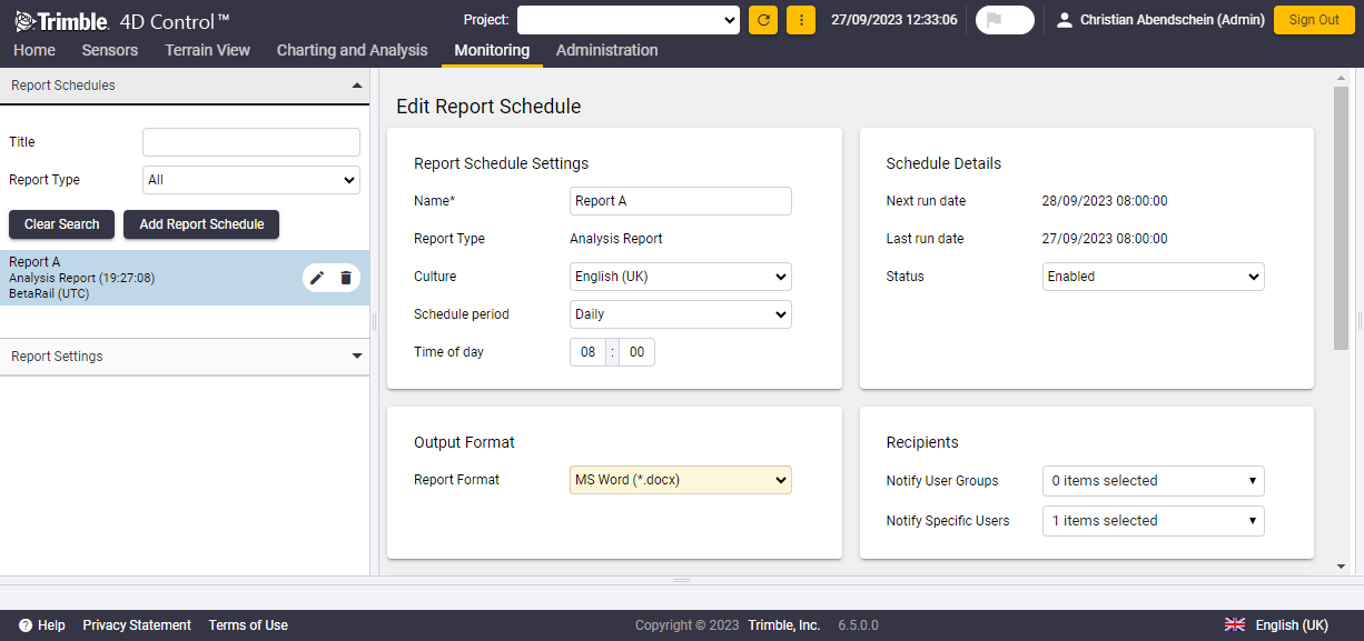
Report output format configuration option
Manual sensor data entry for T4D Access edition
Manual sensor data entry allows users to manually upload data from multiple sensors. In this update users with T4D Access can also make use of the data entry capability. This is particularly beneficial for T4D Access users as this edition does not include automated data acquisition. Next to importing total station data through the Terrestrial Engine PP of T4D Server, this feature offers another option to import manually captured data to the system.
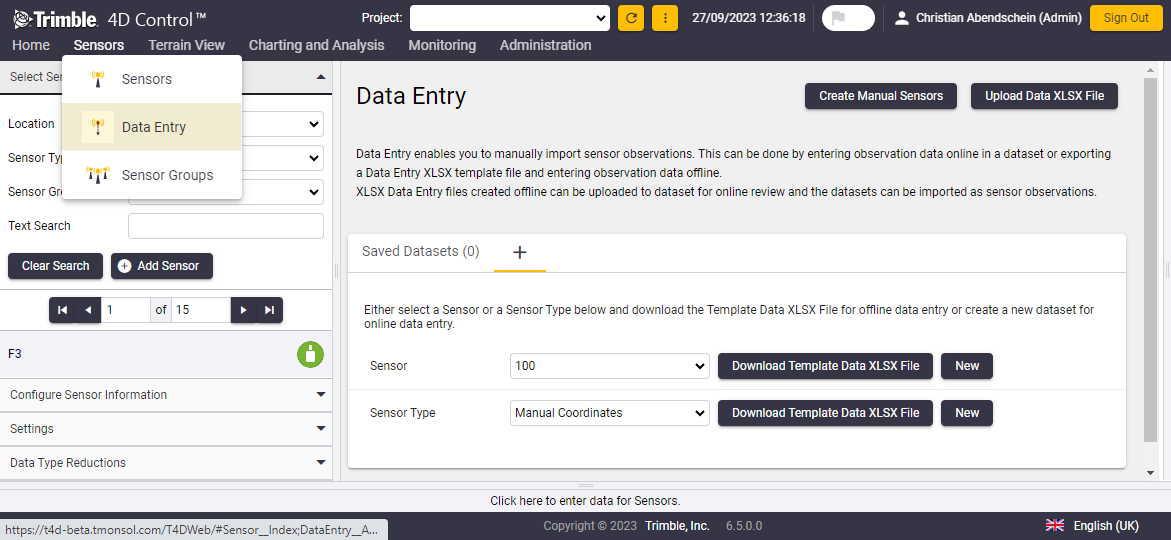 Sensor data entry page
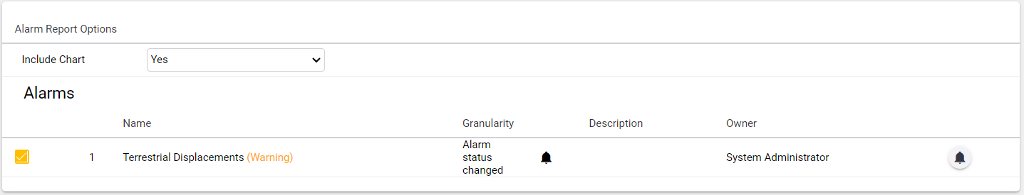
Added alarm charts to alarm report
Alarm reports now have the option to include the alarm charts within the report. Previously, the charts could only be viewed by clicking on the alarm information button inside the web application. This add-on feature allows for all alarm related information to be viewed in one place, simplifying reporting workflows and an easier interpretation of alarm events.
Alarm report configuration
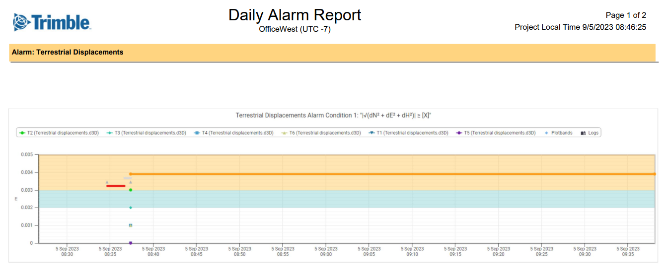
Chart included in an alarm report
Improved handling of gateway connected laser tilt and tilt sensors
Support of temperature data from triaxial laser tilt sensors and tilt sensors
Temperature readings from a triaxial laser tilt sensor and triaxial tilt sensor are now supported and can be used for visualization and analysis purposes at T4D Web.
Addition of specific 'laser tilt' sensor type
An additional sensor type Laser Tilt has been introduced for Geotech Gateway sensors that is tailored for laser tilt sensors. Laser Tilt sensors are now shown in T4D Web as "Laser Tilt" sensors instead of "Optical Displacement" sensors.
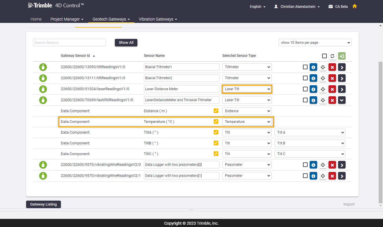
Sensor type Laser Tilt and data component Temperature
Display settings now persisted for analysis charts and reports
Previously, edits done to the Analysis display settings, e.g. line width, point market size, did not save after exiting the view. Now, such edits are saved and persist when revisiting the Analysis. This allows for the owner to customize the Analysis for better data presentation.
Multiple sensor addition now also supports integrated survey data
It is now possible to include Integrated Survey data types when adding multiple sensors. This will simplify the addition of sensors into T4D Web and speed up the process.
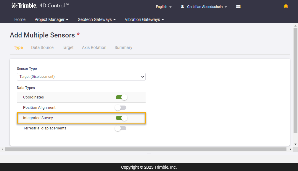
Integrated Survey data type selection
Resolved Issues
-
Target List mixed up - Resolved an issue where adding a target in the T4D site setup would mix the order of the target list and lead to an inconsistency between the target list of T4D and the Settop M1.
-
GeoTiff upload on maps page - File size limit has been increased, previously 256Mb, that allows uploading bigger GeoTiff images and avoids running into error messages when attempting to upload large files.
-
Analysis report only contained the first chart - This issue has been introduced with an earlier version and is now fixed.
-
Add a check for length of analysis project names - An issue has been addressed when the analysis name length exceeds a character count of 50. Users now receive a warning when the name exceeds this limit.
-
Monthly reports were created multiple times in New Zealand Standard Time (NZST) on the first day of the month - An issue has been resolved where reports scheduled for the first day of the month in the New Zealand time zone were generated at a higher frequency. Now reports will only be generated once per month as per user definition.
-
Installer issue with password containing single quote - An issue has been addressed where the installation will not work when the SQL username or password contains an invalid character. A warning message will appear if an invalid character is used.
-
Databases could become huge on Azure systems - The handling of GNSS activity logs has been reworked to prevent needless growth in database table sizes. For related information on Azure database sizing when hosting T4D in the cloud, please refer to the following bulletin.
-
Manual rain gauge sensor - Manual rain gauge sensors no longer include cumulative rainfall data type, this data type is only intended to be used with Vaisala weather stations.
-
Disconnected tilt sensors were still providing data - Addressed an issue where Geotech Gateway sensors may still have provided data after they had been disabled.
-
Historic sensor data flow bug - An issue has been resolved where clicking Clear Search in the historic sensor data flow window would show the time window width unit incorrectly as days instead of hours.
-
Fixed issues with predicted and precise ephemeris - The IGS updated the orbit file naming convention that were not recognized by the Post Processing and RTK Engine. This issue has been addressed with this version.
-
Fixed an IPI (In-Place Inclinometer) data read in error - The outlier validation during IPI data ingestion has been improved so reliable data ingestion and charting is guaranteed even when corrupted or incomplete IPI data files are ingested.
-
Sending alarm emails when Clickatell SMS is enabled but not configured - An issue has been fixed that prevented emails from being sent in case Clickatell SMS notifications were enabled but not configured.
-
Added warning message for analysis reports if large dataset chart included and enabled - Analysis reports allow for data to be included within the report, however, including data for large dataset chart types may have caused a memory overload issue. In order to prevent this issue data is not included in analysis reports for large dataset chart types anymore.
-
Renamed NN into NHN for German language setting - The proper abbreviation for elevation in German has been updated from NN-Höhe to NHN-Höhe. Normalhöhennull (NHN-Höhe) is a datum used in Germany, which references elevation above mean sea level.
System Requirements
Supported Operating Systems
T4D version 6.5 supports the following operating systems:
-
Windows Server 2022 (July 2022)
-
Windows Server 2019 (October 2018)
-
Windows Server 2016 (September 2016)
-
Windows 11*New
-
Windows 10
Supported SQL Servers
T4D version 6.5 supports the following Microsoft SQL servers:
-
SQL Server 2019
-
SQL Server 2017
-
Azure SQL Server
Trimble highly recommends using a full Microsoft SQL Edition that is not subject to limits in memory capacity and more performant (Standard or Enterprise Edition). This is particularly critical for monitoring systems with many sensors and processing engines where T4D Intermediate or T4D Advanced is used.
Supported Browsers
T4D Web is tested on the latest versions of Google Chrome, Mozilla Firefox and Microsoft Edge. Microsoft Internet Explorer is being retired by Microsoft and is no longer supported by T4D Web.
Deployment and Installation
Download of T4D
The installer of T4D version 6.5 is available for download from the Trimble Monitoring website. Some additional information on the installer:
-
It is a single installer for all available software editions of T4D (Access, Field, Intermediate, Geotechnical and Advanced).
-
Depending on the software edition that is selected, the installer downloads only the required installation files.
-
The installer offers a “Download Media” option for an offline installation on a different server that has no internet access. In this case the installer downloads the entire set of installation files for all software editions.
-
The T4D Access, T4D Field and T4D Geotechnical software editions include an automatic download and installation of Microsoft SQL Express 2019.
New installation
To install T4D version 6.5 please perform the following steps:
-
Run the T4D installer executable.
-
Select the T4D software edition you have a license for.
-
Wait for the installation files to be downloaded.
-
Follow the instructions of the installation wizard.
Make sure you have your Microsoft SQL database administrator credentials available if you install the Intermediate or the Advanced Edition of T4D.
Upgrade of existing installations
Before you update your T4D to version 6.5 contact monsol_support@trimble.com to check if your license is valid for T4D version 6.5
To update the software from a previous version to version 6.5, please perform the following steps:
-
Ensure that the existing installation of T4D is running on version 6.0 or later. If not, please update to version 6.0 or later first.
-
Back up all T4D configuration files (*.tde) using the “ConfigurationImportExport” tool that is available from the T4D Server installation directory.
-
Create database backups
-
*.bak using the Microsoft SQL Server Management Studio for SQL databases
-
MongoDB - Next to a SQL database T4D is based on another database management system called MongoDB that handles the organization of monitoring data. For further information on its backup, please refer to this bulletin.
-
-
Run the installation of T4D version 6.5 by clicking on the “Upgrade” tile. The installer automatically detects and uninstalls version 6.0 or later, before proceeding with the installation of version 6.5
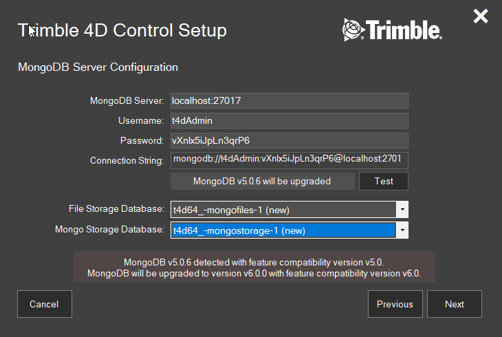
With version 6.5 the T4D installer automatically upgrades the MongoDB version to the latest version and ensures a seamless upgrade of T4D.
For more information, please contact monsol_support@trimble.com.
Appendix
Software Update v6.5.2
There is no software update version 6.5.1. Version 6.5.2 was released in November 2023 and includes all updates implemented since the launch of version 6.5. The following overview provides details about these updates.
T4D Rail improvements
Reworked alarm logic
The T4D Rail module has been enhanced to categorize notifications, emails, and SMS messages according to priority levels. The organization follows a hierarchy, beginning with Rail Section Status, followed by an update on the specific chainage, and concluding with a specific parameter that has changed. This refined system ensures that users are notified only about the most critical change.
Detailed report bugfix
There was an issue regarding outputted data for the track centerline in the Detailed Report. The calculated and displayed parameter data was correct, but the wrong coordinate information was being exported in the report. This has now been fixed.
Trimble Service Administrator (TSA) services shutting down MongoDB
An issue has been resolved regarding MongoDB services being shut down by TSA due to memory overload.
Software Update v6.5.3
There is no software update version 6.5.1. For updates to version 6.5.2, refer to the above section. Version 6.5.3 was released in March 2024 and includes all updates implemented since the launch of version 6.5.2. The following overview provides details about these updates.
Versine calculation issue due to observation age alarm limit exceeded
The observation age parameter enables users to monitor how old the measurement is, which is used for parameter calculation. As of T4D v6.5, when the observation age surpasses the alarm threshold, the calculation stops for affected chainages. This introduced an issue where versine calculations end up missing for all chainages within the section.
Similarly, during semi-automated (manual) monitoring, where measurements were not possible and thus did not exist for specific chainages, the calculation did not occur for the entire rail section. This has now been resolved.
Issue preventing analysis report generation
This software update resolves sporadic issues with the generation of analysis chart images embedded in reports on multi-project installations.
Release notice
This is the March 2024 release (Revision A) of the Trimble 4D Control Software Release Notes. It applies to version 6.5 and subsequent software updates.
