Monitoring 1.1.6
In addition to displacement reporting, the Monitoring application provides a streamlined workflow for repetitive total station measurements that are common for deformation monitoring and precise control workflows.
Monitoring version 1.1.6 released in July 2023. It can be run on both Windows and Android controllers that support Trimble Access, and is compatible with Trimble Access version 2023.00 or later.
New features and improvements
Surface inspection for scan comparisons
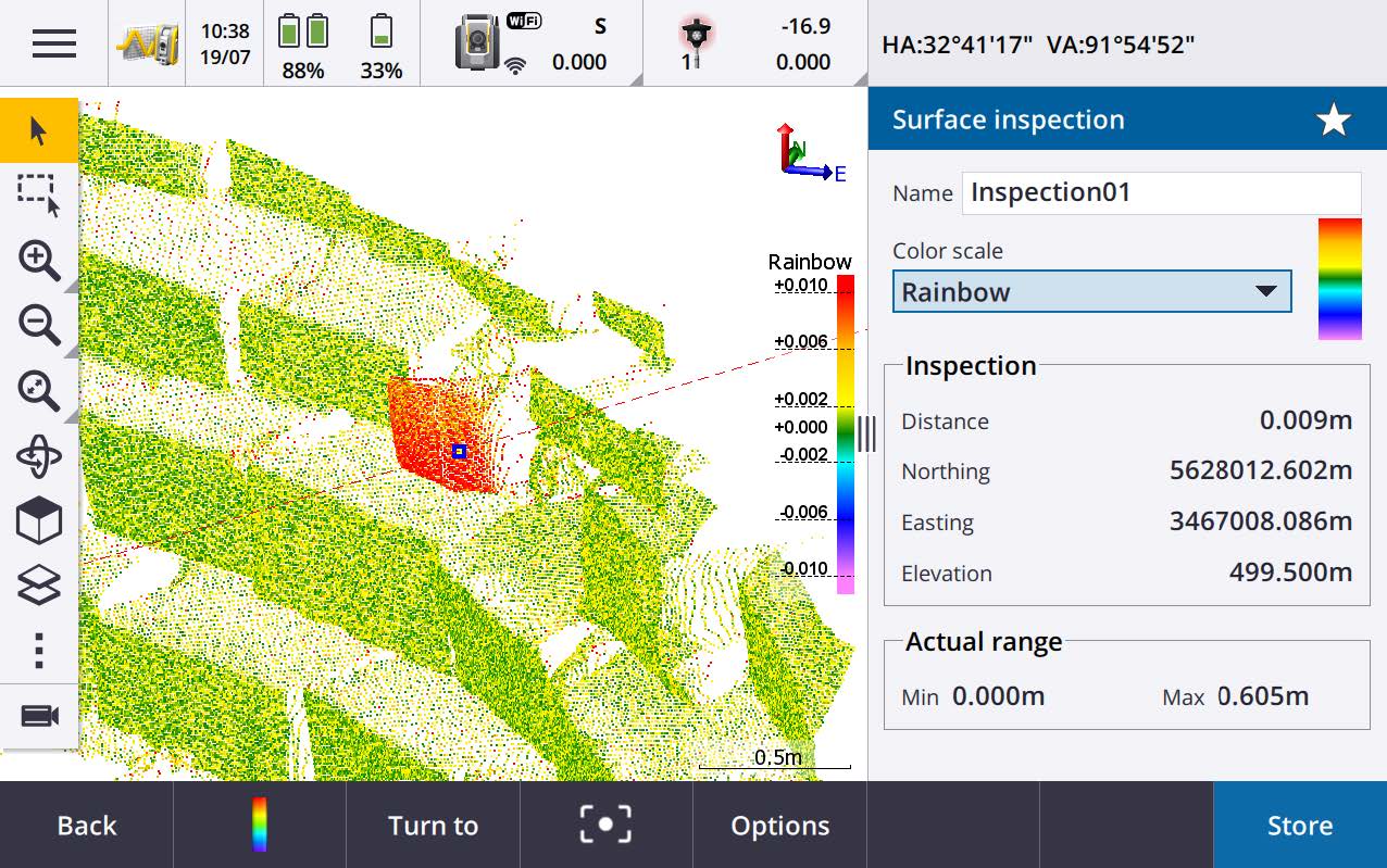
Trimble Access Monitoring version 1.1.6 supports incorporating surface inspections to compare scans collected during monitoring rounds. The surface inspection functionality is located within the Trimble Access Monitoring app.
This function allows a user to undertake in-field surface inspections to compare an as-built scan from the SX10 or SX12 instrument to another as-built scan of another monitoring round or a reference surface. A color-coded inspection point cloud is created and enables a user to immediately see whether there are signs of movement over time.
Typical objects that are monitored using scanning are building facades or dam walls that are monitored to identify whether any sections of the object moved off vertically or the designed inclination. Other applications are landslide and rockfall monitoring, where the user wants to immediately see any parts of the slope or the rock is moving.
For more information, see the topic Surface inspection in the Trimble Access Help.
Optional export of only the latest monitoring round
There is a Data Exchange setting available for T4D Control when choosing to Export Rounds. The setting allows the export process to only generate an export for the latest monitoring round and not all the rounds saved for the current job. This makes the data handling process much more efficient, especially when there can be a job with more than 200 rounds, and only the last round needs to be collected with each new site visit. Note that this setting is not enabled by default. However, once enabled, the setting will persist until disabled.
Description file naming convention for exported monitoring rounds
Trimble Access Monitoring has updated its file naming convention for the exported monitoring rounds when users select the T4D export (.jxl). The new file naming convention is as follows: Jobname_RoundSt#_YYYY-MM-DD.
This new descriptive filing convention provides all the information needed for processing, archiving, and troubleshooting purposes. It clearly states which job the file comes from, what date the measurements were captured and the monitoring round number for the job. The previous naming convention did not include dates, which can add a level of frustration to data handling and file organizing, especially when rounds were collected over several days.
Ability to set the desired number of decimal places for all reports that output distances and coordinates
Users now have the option to control how many decimal places will be displayed in reports generated. For example, the Distance display unit specification visible on the Units page will be responsible for the number of decimal places displayed for distance measurements. The Coordinate display will be responsible for decimal places for coordinate values.
Previously, when creating a report in the Trimble Access Monitoring software, these unit specifications selected within the software did not translate to exported reports. It used to only control what was displayed within the software.
For more information, see the topic Units in the Trimble Access Help.
More intuitive and effective orientation workflow
To be able to perform a station setup as quickly as possible in case the instrument comes back to a previously used setup location, Trimble Access Monitoring provides an orientation function. For this purpose, the orientation of the previously used station setup is automatically stored, and Trimble Access Monitoring calculates the respective horizontal angle and distance differences when performing a new orientation. To save time and to avoid any confusion unnecessary user interactions have been automated.
Resolved issues
-
Reports providing values in meters and displaying the units in meters when users select International feet in the Units specification page have been resolved. Both values and units are now provided and displayed in International feet when selected.
-
The Add Point button is now always available when the total station video view is open.
-
We have fixed an issue where images were not taken if monitoring points were created by importing a point list whose points had the image capture setting enabled.
-
Failed to export a Trimble Business Center (TBC) .json file if there was only one monitoring round.
-
Failed to convert timestamps to UTC in preparation for TBC in order for the timestamps to appear in the time zone consistent with the computer’s settings.
-
Failed to use the correct sign on Android controllers when converting timestamps to UTC in preparation for Trimble 4D Control (T4D), in order for the timestamps to appear in the time zone consistent with the computer’s settings.
-
An issue has been resolved when Target 1 of the target definition is configured to be an active target. Monitoring rounds can now be measured seamlessly
