
String interpolation
The following rules apply to keyed‑in station values:
- For an alignment (6D string), the coordinates for keyed‑in station positions are computed respecting the geometry of the string. Elevation values are computed by linear interpolation. However, if there is a 12D string coincident with the 6D string, the software uses the vertical alignment data available in the 12D string to compute the elevation values.
-
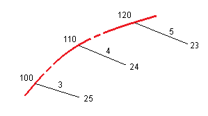
For a 3D string, the offset and elevation values are interpolated from the offset and elevation values of the previous and next positions on that string. This ensures the integrity of the design, especially on tight curves. See the following example where the cross section at station 100 has a string offset from the 6D string by 3 and an elevation of 25. The next cross section at station 120 has a string offset by 5 and an elevation of 23. The position on the string for the interpolated station 110 is interpolated as shown to give an offset of 4 and an elevation of 24.
However, if the deflection angle of the 3D string compared to that of the associated 6D string is greater than 30 minutes, the geometry of the associated 6D string will be ignored and the coordinates will be computed by linear interpolation instead. This is to avoid unexpected behavior when there is an acute change in direction in the 3D string for features such as slip lanes, bus bays, and so on.
- Interpolation between points along a transition is calculated using a clothoid spiral for 12D and 6D strings and approximated for 3D strings.
When measuring your position relative to a GENIO road or where your station and offset are nominal values your position is computed by linear interpolation from the nearest positions on adjacent strings.
In all situations where your position is interpolated, closer station intervals give greater accuracy.