Using a TruPulse laser rangefinder to measure offsets
NOTE – To connect to a Trimble HPS2, see Using a Trimble HPS2 handle.

 To connect to the rangefinder in TerraFlex
-
Make sure the rangefinder is turned on and Bluetooth is enabled. For more information, refer to the laser rangefinder manufacturer's instructions.
-
In TerraFlex tap
/ GNSS configuration.
-
Scroll down to the Laser Rangefinder section, then tap > to list available rangefinders.
-
A list of supported devices displays.
If the rangefinder you want is not listed, tap Scan for more devices. If there are a number of Bluetooth devices in the vicinity you may need to refresh the list a couple of times. You may need to scroll down to see all devices.
Tap the rangefinder that you want to connect to.
When the rangefinder is connected, the software returns to the GNSS configuration screen.
-
Make sure the antenna height of the GNSS receiver is correct. In the Antenna Height field, enter the distance from the ground to the bottom of the antenna when it is mounted on the pole you are using.
-
To accurately capture the height of features captured remotely, enter the Laser Height of the rangefinder.
The Laser Height value is the distance from the ground to the bottom of the laser when it is mounted on the pole you are using. If you are not using a pole it is the distance from the ground to the bottom of the laser at the height at which the rangefinder is used (your eye height).
 Measuring offsets in TerraFlex
NOTE – The type of offset measured by the TerraFlex software depends on the capabilities of the connected laser rangefinder. When connected to:
-
A LaserTech TruPulse 360i or 360° laser rangefinder, the TerraFlex software uses the bearing sensor in the laser rangefinder to measure a distance‑bearing offset.
-
A LaserTech TruPulse 200, 200X, or 200i laser rangefinder, the TerraFlex software always measures a distance‑distance offset.
To measure a distance‑bearing offset
-
Make sure the rangefinder is operating one of the available distance modes, that is SD (Slope Distance), HD (Horizontal Distance) or VD (Vertical Distance) mode. For more information, refer to the manufacturer's instructions.
-
In the map in TerraFlex, tap
(Log with offset).
-
Move to the location you want to use as a starting point and log your current position.
-
Use the rangefinder to measure the offset from your current position to the asset you are capturing.
-
If the captured offset is within the accuracy threshold, or outside the accuracy threshold but you can allow it, tap Accept.
- If the captured offset is outside the accuracy threshold and you are not permitted to accept it, tap Refine. Move 90 degrees around the asset and repeat steps 2 through 4 above.
- To save the collected offset, tap
 .
.
To measure a distance‑distance offset
-
 Make sure the rangefinder is operating one of the available distance modes, that is SD (Slope Distance), HD (Horizontal Distance) or VD (Vertical Distance) mode. For more information, refer to the manufacturer's instructions.
 -
In the map, tap
(Log with offset).
-
Move to the location you want to use as a starting point and log your current position.
-
Use the rangefinder to measure the offset from your current position to the asset you are capturing.
-
Move 90 degrees around the asset and log another position.
-
Use the rangefinder to measure the offset from your position to the asset you are capturing.
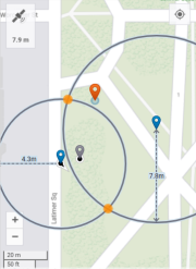
The software uses the two reference positions you logged and the distance values from the rangefinder measurements to calculate two intersecting circles that show the two possible locations of the asset and shows them on the map:
-
the two blue map pins indicate the reference positions;
-
the two solid yellow discs indicate the two possible asset locations.
-
-
From the two highlighted asset locations on the map, tap the solid yellow disc that is the correct location of the asset. If you are not sure which location is correct, walk toward the asset.
-
If you are not able to get closer to the asset, or if the selected location is outside the accuracy threshold and you are not permitted to accept it, tap Restart and then repeat steps 3 through 7 above.
-
To save the collected offset, tap
 .
.
TIP – If the software is unable to calculate a good position, an alert appears at the top of the screen. The most common issues when using a laser rangefinder are when magnetic disturbance is detected, such as when you are near metallic objects, or a bearing error. In these cases the alert will suggest moving to a different location to retake the measurement.