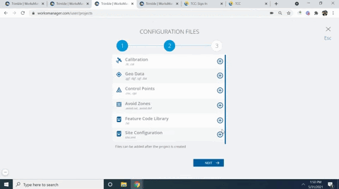
Add Configuration Files
-
Click + next to any of these Configuration File types to add them as site data:
-
Calibration (.dc or .cal) - Add this file to establish the relationship between WGS-84 positions (latitude, longitude, and ellipsoid height) determined by GPS observations and local known coordinates defined by a map projection and elevations above mean sea level. The parameters are used to generate local grid coordinates from WGS-84 (and vice-versa) in real-time in the field when using RTK surveying methods.
-
Geo Data
-
Geoid (.ggf) - Add this file to include a hypothetical ‘surface’ of equal gravity potential that approximates mean sea level (it is normal to the gravity vector at every point) Similar to an ellipsoid, the geoid surface is not a uniform mathematical shape, but is an irregular figure. Generally, the elevations of points are measured with reference to the geoid. Currently, there is no conflict resolution if this is different in TBC. They can be out-of-sync.
-
(.dgf) - Add this file to use a datum grid If you have chosen a coordinate system for your project that uses a datum.
-
(.sgf) - Add this file to use a shift grid, which is a transformation grid that is applied to a projection to correct the initial projection coordinates. Shift grids are generally used to correct local distortions in a regional survey framework that cannot be modeled by a simple transformation.
-
(.dat) - Add this file to use a SnakeGrid® file. Snake grids enable surveyors working on long, linear projects (highways, railways, and pipelines) to have a coordinate system with scale factor distortion of less than a few parts per million for the length and width of the construction corridor. A coordinate system with a SnakeGrid uses projections to perform transformations between local northing/eastings and their corresponding latitudes/longitudes. Intervening points are calculated by interpolation.
-
GCS900 calibration (.cfg) - Add this file to set the default coordinate system based on an absolute origin and orientation.
-
-
Control points (.csv, .cpz) - Add this file to include permanently marked locations to be used as reference points for survey or mapping work. The coordinates of a control point are determined with a high degree of accuracy using terrestrial and/or satellite surveying techniques.
-
Avoid zones (.avoid.svl, .avoid.dxf) - Add this file to delineate closed areas that an Earthworks or Groundworks machine or a Siteworks field device is restricted from entering. A proximity warning appears on the machine or controller's display if it approaches the avoidance zone. Avoidance zones are used in the field to deter people and heavy equipment from entering restricted areas on a job site.
-
Feature code library (. fxl) - Add this file to include alphanumeric strings (abbreviations) used to identify features (objects found in the field, e.g., trees, hydrants, utility poles, etc.) in the field and during feature code processing. Currently, there is no conflict resolution if this is different in TBC. They can be out-of-sync.
-
Site configuration (site.xml) - Add this file (created using the older field data workflow for job sites) to include project units written for a specific data collector's project folder.
