Define the Project Boundary
-
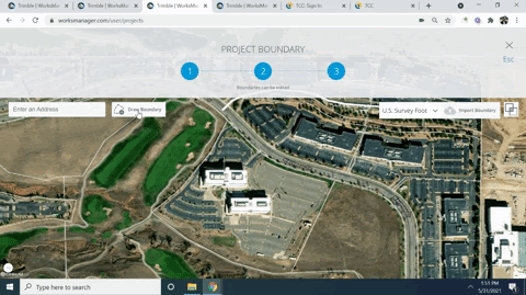
When the Map View opens, enter the address of your project’s job site, and zoom in to the extent that you can draw an accurate boundary. You can click-and-drag to pan the view.
-
Click Draw Boundary, and pick points in the map view to draw a polygonal boundary representing the extents of the site. This boundary is used as a ‘geo-fence’ that determines whether your Siteworks field devices or Earthworks machine control boxes are ‘on-site’.
-
Click OK to close the boundary, and click FINISH.
Your project appears in the Active Projects list, ready for you to synchronize data with TBC, Siteworks, or Earthworks.