Run a Corridor Earthwork Report
Run a Corridor Earthwork Report to perform a mass earthwork analysis and compute subgrade quantities for a corridor using the average end area method. The report runs along the entire length of the corridor, unless you restrict it to within a specified subsection. The accumulated bank excess/deficit volume and, optionally, the accumulated cut and fill volumes at each station are reported.
Note: The ability to show strata materials in the report pertains only to the Launch Excel Data Only report output type. When the report is displayed in the Report View within the program, information on strata materials is not included.
|
|
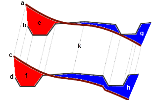
Note: The illustration above does not portray refinements such as curve corrections or differences in material density states between cut and fill volumes.
Prerequisites:
- License; See the Subscription Plans page. For a license matrix by command, see the License page in the TBC Community. Also see View and manage licensed features.
- Corridor
- Original ground surface (also specified in the corridor's properties)
To access the command:
Do one of the following:
- Select Reports > Report Options in the Quick Access Toolbar and then double-click Corridor Earthwork Report in the list.
- Select Corridor Earthwork Report in Corridors > Reports.
- Right-click a corridor, and select Corridor Earthwork Report from the context menu.
The Corridor Earthwork Report command pane displays.
To run a Corridor Earthwork Report:
- Select the corridor that you want to calculate volumes for in the Corridor list.
- In the Station Increment box, specify the distance between stations at which you want to compute the average end area volumes. The first station may be odd or irregular up to the first instance of the increment specified.
- To limit the computed end areas to those within a boundary, pick one or more closed polylines in the Plan View from the Optional clipping boundary box. If the corridor earthworks report is generated using the Excel format, earthworks volumes within each boundary will appear on a separate page. If the corridor earthworks report is generated using the HTML format, earthworks volumes within each boundary will appear in separate reports. Ensure you give meaningful names to your boundaries so the separate reports or Excel pages are easily identified.
- To report only on a portion of the corridor, check the Only include subsection box. Then specify a station range in the Start station and End station boxes.
The start and end station controls are disabled unless you specify a range. The disabled controls are populated with the start/end when you pick a corridor. - Check boxes to include specific data in the report:
- Compute bank volumes only - Select this if you have not previously defined earthen materials and their shrinkage and bulkage factors within the Material and Site Improvement Manager, you have not assigned a native or fill/borrow material to the corridor, or you simply do not wish to account for material shrinkage and bulkage in determining volumes.
- Account for shrinkage and bulkage - Select this if you have previously defined earthen materials and their shrinkage and bulkage factors within the Material and Site Improvement Manager, and you have assigned a native and borrow material to the corridor, and you wish to use those factors to perform a more accurate mass earthwork analysis.
- Account for curve adjustment - Check this box to factor (in the cut/fill volumes) the effects of the longer path swept by areas on the outside of curves in the corridor, in comparison to those on the inside. Areas on the outside increase the computed volume, whereas those on the inside decrease it.
- Include horizontal alignment points - Check this box to report the cut/fill volumes at the location of each horizontal alignment point of intersection (PI), i.e., PCs, PTs, etc.
- Include vertical alignment points - Check this box to report the cut/fill volumes at each vertical alignment vertical point of intersection (VPI), i.e., VPCs, VPTs, etc.
- Select options in the Display Options group,:
- Show accumulated cut/fill - Include columns in the report to show the total cut and fill volumes that have accumulated from the start station up to each reported station.
- Current content style - This shows the style of the report as defined in Report Options. To change this setting, click the Report Options icon on the pane's toolbar, select the report, and visit the Settings group.
- Explanatory includes text describing how report results were derived or calculated.
- Concise hides the explanatory text.
- Click . The report displays on a new Report View tab.
Scenarios:
- If your alignment is longer than the associated corridor, only the areas where they are coincident are used in the report.
To change report settings:
- Select Reports > Report Options in the Quick Access Toolbar.
Report option settings:
- Float (Undock) - open the report in a separate window.
- Launch excel data only - An Excel report will be generated. This report has additional information including:
- the amount of each material cut from surface (when a corridor strata is defined).
- the amount of subgrade material required (when the template definition includes subgrades).
- the surface area of each material layer, computed by, multiplying the average slope length by the change in station. The "material layer" (adjusted) surface is the surface area of each material layer adjusted for curve and grade slope.
Dependencies:
- The volume calculations are dependent on the corridor and its associated original ground surface.
