Understanding Corridor Strata
Strata perpendicular to a corridor can be determined at any station along the horizontal alignment and used to determine the volume of each material cut from the surface. The corridor strata is determined from existing strata surfaces or interpolated from corridor boring logs.
Surfaces
If you have surfaces which are a good representation of the material layers under the original surface, use these to define the strata. In the Define Corridor Strata box select Surfaces asthe Strata definition method and enter the surfaces in the surface column. You must define a surface for each material. At any point the surface directly above will determine the material at that point.
Example:
The strata definition is
|
Material below surface |
Surface |
|
Sandy silt |
Original ground (yellow) |
|
Sandy clay |
Top of sandy clay (red) |
|
Clay |
Top of clay (orange) |
If the surface directly above a point is "Top of sandy clay", then the material at that point will be sandy clay.
When surfaces cross the surface lower in the list takes precedence.
Example:
In the diagram below, the surface "Top of clay" crosses the surface "Top of sandy clay". The surface directly above the arrow is "Sandy Clay" but since this point is also below "Top of Clay" which is lower in the strata definition list, the material at this point is considered clay.
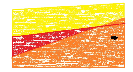
Warning: It is highly recommended that you do not use strata surfaces that cross. Doing so will produce inconsistent results between the cross-section volumes and the surface-to-surface volumes. See Define and Edit the Strata for a Corridor.
Boring logs
If you have boring log data for the corridor, use these to define the stratum. In the Define Corridor Strata box, select Boring logs from the Strata definition method list and enter the order of materials below the original ground surface. The surface column is not applicable when defining strata by boring logs.
Tip: If you have boring log data as X,Y.Z values, you can import them as points. Then create surfaces from the points, and use the surfaces as corridor strata.
Note: Surfaces created from strata have the Adjust for arc/chord property set to No by default.
When determining the location of the boring logs, the following should be considered:
- the extents of the corridor's footprint
- the need to place sufficient boring logs either side of the corridor
- the need to keep the stationing of boring log similar (within the discovery tolerance you plan to set for the project) when boring logs are observed at multiple offsets from a station
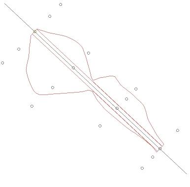
The following diagram shows good positioning of bore holes.
If the location of the boring logs has been pre-determined, make sure you get optimal results by carefully setting the discovery tolerance in Project Settings. In the following example, the grouping of boring logs can be modified by changing those settings for boring logs.
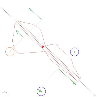
Example: Assume the Boring log discovery tolerance is set to 20 m and the Boring log max offset is set to 100 m. To determine the corridor strata at the station marked with a red dot, a search for boring logs is made backwards from the station. When a boring log is discovered (circled in red) the search continues for other boring logs within the Boring log discovery tolerance of the first boring log found and the Boring log max offset. With a discovery tolerance of 20 m, other boring logs are not found. A strata will be created at the site of the first boring log using a single boring log's data. Another search for boring logs is made moving forward of the station. The first boring log found is within 20 m from the next boring log. These boring logs are also within 100 m of the alignment, satisfying the Boring log max offset. In this case, both boring logs (circled blue) will be used to create the corridor strata (at the station of the first boring log found). The final boring log is not found because it is outside the discovery tolerance. Depending on the terrain and the geology of the site, you may want to use all three boring logs to determine the strata at the first boring log. Increasing the discovery tolerance to 80 m will find all three boring logs searching backwards from the station and all three boring logs searching forwards of the station. This may give a more accurate representation of the strata. (Ideally all three boring logs would be measured at the same stationing.)
Tip: Use the Measure command to determine the station delta between the first and last boring logs that you want grouped to determine a good discovery tolerance setting.
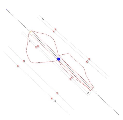
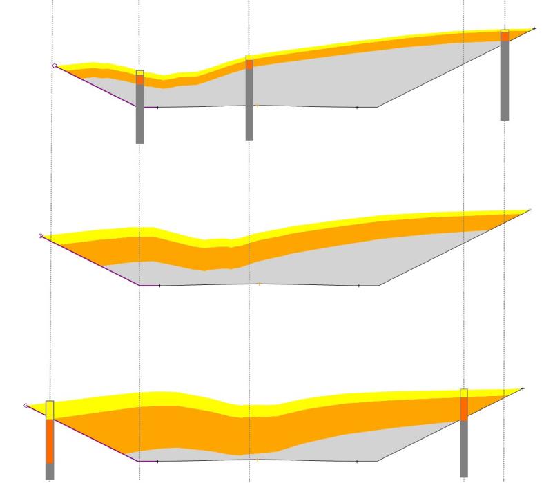
Interpolating strata at a cross-section
Two cross-section strata, forwards and backwards from the station, are formed. These strata are used to interpolate the cross-section strata at the station (blue dot). Given that all boring logs are within the tolerances, nodes are formed at points marked with a red x.
Thickness of the stratum is interpolated:
- at nodes where boring log data is not available
- at points along the surface
Once a strata is determined at cross-sections (forwards and backwards from the station) a strata is interpolated at the station. In the cross-section diagram below, the cross-section in the middle has been interpolated from the corridor strata cross-sections either side of the station.
Scenarios
- If a single boring log is used to determine the corridor strata at a station, the strata follow the original surface and the stratum thickness is maintained.
- If the extents of one cross-section stratum is greater than the other, the narrower cross-section is extended. The strata follows the surface and the strata thickness is maintained.
- If all boring logs are outside the Boring log max offset tolerance, strata are not formed. The native material defined for the corridor is used as the cut material instead.
If the original ground surface defined for the corridor does not match the original ground surface defined in the corridor strata definition, strata are not formed. The native material defined for the corridor will be used as the cut material instead.
Reporting different materials
To report on the amount of each material in the corridor strata that is cut from the surface, run the Corridor Mass Haul Report or the Corridor Earthworks Report (use the Launch Excel data only option).
Example: Assume the Boring log discovery tolerance is set to 20 m and the Boring log max offset is set to 100 m. To determine the corridor strata at the station marked with a red dot, a search for boring logs is made backwards from the station. When a boring log is discovered (circled in red) the search continues for other boring logs within the Boring log discovery tolerance of the first boring log found and the Boring log max offset. With a discovery tolerance of 20 m, other boring logs are not found. A strata will be created at the site of the first boring log using a single boring log's data. Another search for boring logs is made moving forward of the station. The first boring log found is within 20 m from the next boring log. These boring logs are also within 100 m of the alignment, satisfying the Boring log max offset. In this case, both boring logs (circled blue) will be used to create the corridor strata (at the station of the first boring log found). The final boring log is not found because it is outside the discovery tolerance. Depending on the terrain and the geology of the site, you may want to use all three boring logs to determine the strata at the first boring log. Increasing the discovery tolerance to 80 m will find all three boring logs searching backwards from the station and all three boring logs searching forwards of the station. This may give a more accurate representation of the strata. (Ideally all three boring logs would be measured at the same stationing.)
