Export Mobile Mapping Panoramic Images and Trajectory Files (.csv)
The Trimble MX Panorama export feature lets you speed up the conversion of the data to be used in the Trimble TMXsoftware, i.e. panoramic Images and trajectory, without waiting until the generation of cubical images in TBC is completed.
To export mobile mapping panoramic images and trajectory Files (.csv):
- Import a Trident project file (.tridb) into an existing VCE project.
- When the import is finished, and without waiting for the generation of the cubical images to be completed, press Cancel in the Process View pane.
- Select Export in Home > Data Exchange to display the Export command pane.
- Click the Mobile Mapping tab.
A list of available exporters displays.
- Select MX7 Export to TMX in the list.
No selection of Mapping Run is required. You can leave the default selection at 0.
By default, the name in the File Name field is the name of the VCE project. The default location is in the project folder.
- Optionally, in the File Name field, enter a different file name and/or file path.
- Click in the Panorama Export Settings pull-down arrow and choose:
- No to not export the GPS attributes in the panoramic images files.
- Yes to export the GPS attributes in the panoramic images files.
- Optionally, blur the images (see Blur Exported Images).
- Click Export to export the data.
A set of panoramic image files is created. All reside in a folder / sub-folder under the project folder. The created sub-folder is named according to the Tridb project name, while the parent folder has the name given at the export. Each panoramic image, named Pano, has a size of 8000 X 4000 pixels.
In addition to the panoramic image files, two CSV format files are created: one for the panoramic images and the other for the trajectory data.
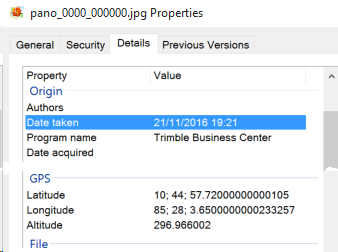
A panoramic image file for which the GPS attributes have been exported, when displaying its properties, shows the following information i.e., its latitude, longitude and altitude, as well as when it has been acquired: