Create Points Using Double Proportioning
The Double Proportioning command enables you to determine the location of a missing position marker based on record distances (grid or ground) and bearings from four known positions located at cardinal points around the missing marker. After calculating the position of the missing marker, a point is created at the position for which you can specify the point ID, layer, and feature code. In addition, you can generate a report to verify the results of the double proportioning process.
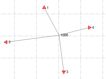
In the following example, a new double proportioning point (1000) has been created on a missing marker's position using record distances and bearings from four know positions (1 through 4).
To create points using double proportioning:
- Select Double Proportioning.
- Select the appropriate Calculation type:
- Planar (grid) is appropriate for proportioning along straight lines that are 1 km or less.
- Geodetic (global) is appropriate, due to the earth's curvature, for proportioning along straight lines that are greater than 1 km.
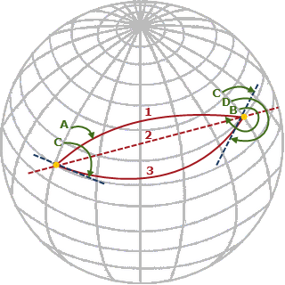
Note: With geodetic calculations, the resulting rhumb lines are spirals; therefore, if their length exceeds 20 km, they cannot be measured accurately using the Inverse command. To see a comparison of a geodesic path (used by the Inverse command) and a rhumb line (used by the Double Proportioning command),
 click here.
- In the Direction group box, click the North option and do the following:
- Click in the Northern know position field and do one of the following:
- Select an existing point in the Plan View.
- Type in a coordinate for the position.
- Select the position in the Plan View.
- In the Northern Record Distances list, do either of the following:
- Type in (or select in the Plan View) one or more record Bearing/Distance pairs that define the path from the selected position to the position of the missing marker. You can enter the bearing/distance pairs in any sequence. In addition, the bearing directions do not matter. For example, a bearing of N30E and a bearing of S30W yield the same results.
- If line work representing one or more record Bearing/Distance pairs that define the path from the selected position to the position of the missing marker exists, click in the Select segment field and then select the lines in the Plan View. You can select the lines in any sequence.
Once you have entered valid distance and bearing values for the North position, a green "ready" indicator displays to the right of the option. Each distance/bearing pair is reduced to its cardinal equivalent and summed with the cardinal equivalents from its siblings. This value is displayed as the Total cardinal equivalent.
- Click in the Northern know position field and do one of the following:
- Repeat for each of the other three cardinal directions.
- If you selected the Geodetic Calculation Type option, select to use Grid or Ground for Record Distances.
Your selection does not make much difference on a small projects. But for larger projects you should choose the option that most accurately describes the record distances.
- Optionally, in the Starting point ID field, change the default ID displayed.
The new double proportioning point will be assigned this ID. If additional points are created (see step 8), they will be named in the sequence north, east, south, and west (for example, 1000, 1001, 1002, and so on).
- Optionally, change the Layer on which the new points will be displayed.
- Check any of the check boxes as appropriate:
- Create points at known positions - Create a new point on each of the known positions.
- Create lines - Create one or more new line segments from the known position to the new double proportioning point. You can delete these line segments later if you want.
- Create report - Generate a report describing the results of the proportioning. This report is not saved in the project and cannot be re-opened at a later time.
- Click the Apply button to create the new point and, optionally, new lines.
If you do not obtain satisfactory results, press Ctrl+Z to undo the action. Then make changes as necessary in the Double Proportioning command pane before trying again.