Integrate Points into Geometry
Use the Integrate Points into Geometry command to automatically convert vertex coordinates for linestring-based polygonal objects and COGO parcels into points.
Prerequisites:
- See the Subscription Plans page. For a license matrix by command, see the License page in the TBC Community. Also see View and manage licensed features.
- If you are assigning feature codes to the new points, import the appropriate Feature Definition library into your project.
- one or more points, linestring-based polygonal objects, and/or COGO parcels
To integrate points into geometry:
- Select Integrate to Geometry in CAD > Points or in Survey > COGO to display the Integrate Points into Geometry command pane.
- Click in the Select points and geometry field and then, in the Plan View, select one or more points, linestring-based polygonal objects, and/or COGO parcels whose vertex coordinates you want to convert to points. Or, click the Options button for more selection options.
CAD polylines, COGO linestrings, boundaries, and breaklines are not supported.
- In the Starting point field, enter the point ID to assign to the first point created.
All subsequently created points will increment accordingly in a clockwise sequence.
- Optionally, in the Point feature code field, enter the feature code you want to assign to the new points. Or, click the button located to the right of the field to open the Feature Code Editorto make your selection.
- Click the Process button.
Processing can take a long time for large datasets. A progress bar on the Integrate to Geometry pop-up window shows the current status. Click the Cancel button to cancel the process.
A new point is created for each vertex in the selected polygonal object(s) that is not already defined by a point. The new point ID is displayed in the Plan View and Project Explorer.
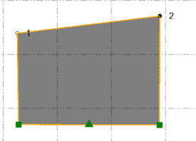
The following example shows a polygon with point IDs defining two of its corners and coordinates defining the other two:
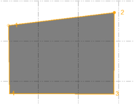
After running the Integrate Points into Geometry command, the other two corners are now defined by new points so that all of the linestrings are now based entirely on points.
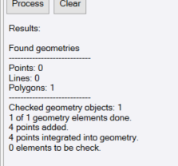
The results of the process are displayed in the lower portion of the command pane.