Create Orthomosaics from a Trimble Back-Camera Mobile Mapping System
Use the Ortho Lane command to create orthorectified images combined in a single orthomosaic based on images captured by a Trimble Mobile Mapping system with a back-facing camera. As part of the overall pavement inspection workflow, the resulting auto-generated orthorectified images can be used for the automatic computation of crack dimensions (including crack width) using the Inspect Pavement Condition command.
Prerequisites:
See the Subscription Plans page. For a license matrix by command, see the License page in the TBC Community. Also see View and manage licensed features.
To create orthomosaics from back-facing Mobile Mapping cameras:
- Select Ortho Lane in Mobile Mapping > Analysis to display the Ortho Lane command pane.
- Click in the Select Mobile Mapping run field and then select in a graphic view or the Project Explorer the Mobile Mapping run that includes the back-facing images you want to process.
- Optionally, to select a smaller section of the entire run for processing, check the Precise selection check box, click in the Start field, and select a start point on the selected run. Repeat for the End field.
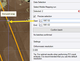
- Click the Confirm batch button.
To add more than one batch, repeat steps 2-4 for each batch.
Click the Discard last batch button to discard the most recently added batch.
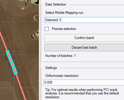
- Optionally, change the default Orthomosaic resolution.
A resolution of 0.005 m is recommended if you are performing crack analysis using the Inspect Pavement Condition command.
- Click the Generate button.
The status of the process is displayed in the TBC Status Bar. When complete, the new OrthoLane_.tif image file is created in the ProjectName\Ortholane folder and imported into the project, as shown in this example where the point cloud has been hidden.
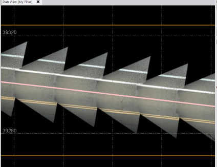
The orthorectified images can now be used for the automatic computation of crack dimensions using the Inspect Pavement Condition command.
