Mobile mapping
Import and process data from Trimble mobile mapping hardware platforms like the MX9, MX50, MX60 and MX90.
-
Manage point cloud processing, classification, registration and deliverables of one or multiple projects with MM Batch Processing tools.
-
Post-process raw trajectory data against local base stations or CORS networks.
-
Adjust, colorize, and register scan data with single run or multirun options and precise target-picking tools.
-
Take advantage of powerful registration tool to align scans from one or from multiple missions.
-
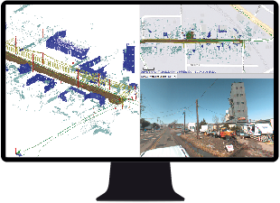
Navigate your reality capture data in the multiple views for image and for 3D scan data. Overlay your reality capture data to display scans and images in a combined view.
-
Perform road pavement inspection workflows with the PCI and the IRI tool.
-
Export data to third-party and Trimble software such as TMX, Mapillary, TopoDOT, Solv3D, and Horus.
Work with trajectory, registered point cloud, and imagery.
Resources
Video/webinar link
Trimble Learn courses
Help topics
