To stake an offset point
When staking a point using the default GNSS stake method To the point you can stake an offset point defined by an azimuth and offset from the point.
You can also define a second offset point on the same azimuth as the first offset point.
- When navigating to the point, tap Offset.
-
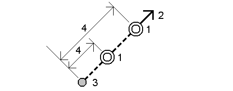
Use the fields in the Offset screen to configure staking out points (1) at an azimuth (2) from a point (3) and offset by a horizontal distance (4).
The elevation for each offset point can be defined by:
- Slope from point – the elevation is computed by a slope from the elevation of the point selected to stake.
- Delta from point – the elevation is computed by a delta from the elevation of the point selected to stake.
- Key in – the elevation is keyed in.
NOTE – If the point has no elevation, the elevation for the offset points must be keyed in.
-
Tap Accept.
The map shows the selected point and the first offset point.
- Navigate to the offset point. See Stakeout navigation.
-
When the point is within tolerance, measure the point. Tap Store.
If you have defined a second point, it is shown on the map.
-
Navigate to the second offset point.
-
When the point is within tolerance, measure the point. Tap Store.
If you are staking points from a list, the software returns to the stakeout point list.
