View a Project's Feature Library
When you import a Feature Definition (.fxl) file into your project, the contents of the the file are loaded into the project's Feature Library where it can be used to process feature codes. You can also create a Feature Library from "scratch" directly in your project. The contents of the Feature Library are displayed in the Project Explorer.
To view a project's Feature Library:
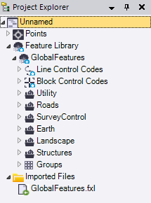
- In the Project Explorer, click to expand the Feature Library node to view the contents of the library. Click to further expand any Feature Library child node as necessary.
The following example shows a project into which the default GlobalFeatures.fxl file (installed with TBC) has been imported.
- To automatically jump from a feature in the Properties pane to that feature's entry in the Feature Library, click the Show Feature Definition
 button.
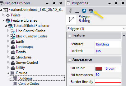
- To view or edit a control code or feature definition, double-click its node or right-click it and select Properties.
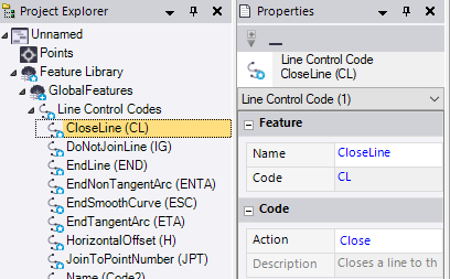
- Line Control Codes - Surveyors can assign line control codes to points during field data collection to specify properties for an associated line feature. For example, they can assign a line control code to a point to specify where a feature line starts or ends. When the feature codes are processed, line control codes modify line objects according to the actions (instructions) associated with the code.
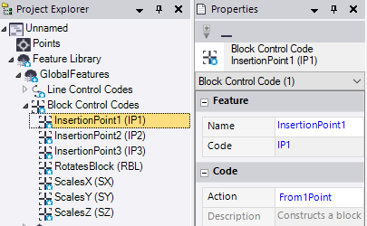
- Block Control Codes - Surveyors can assign block control codes to points during field data collection to specify properties for an associated block feature. For example, they can assign a block control code to a point to specify to scale the feature block on the X, Y, or Z axis. Or, they can assign block control codes to one to three points (depending on the block definition) that are used as insertion points for the block.
When the feature codes are processed, block control codes modify block objects according to the actions (instructions) associated with the code.
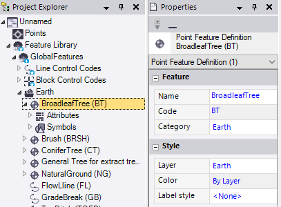
- Point feature definitions - A point feature is used to identify a single feature, such as tree or utility pole. It typically includes one or more feature attributes and a representative symbol that displays in graphic views.
Related point feature definitions are typically grouped in the same category (for example, all landscape-related point feature definitions might be grouped together in a Landscape category). You can edit a definition's properties, supported attributes, and symbol as necessary.
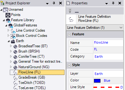
- Line feature definitions - A line feature is made up of two or more points that define a line, such as a fence or path. A line feature may also include line control codes that are used to further define linear features (for example, add lines, curves, and arcs between points) and one or more feature attributes.
Related line feature definitions are typically grouped in the same category (for example, all road-related line feature definitions might be grouped together in a Roads category). You can edit the definition's properties (including how the line displays in graphic views) and supported attributes as necessary.
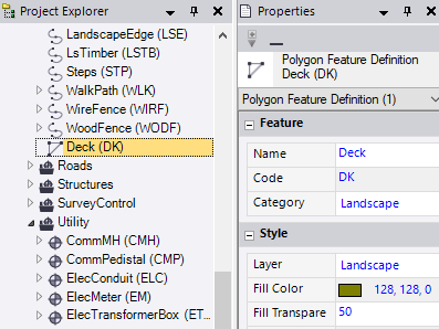
- Polygon feature definitions - A polygon feature is made up of three or more points that define the border lines for a polygonal shape, such as a concrete pad or retaining wall. A polygon feature may include one or more feature attributes.
Related polygon feature definitions are typically grouped in the same category (for example, all structure-related polygon feature definitions might be grouped together in a Structures category). You can edit the definition's properties (including how the polygon displays in graphic views) and supported attributes as necessary.
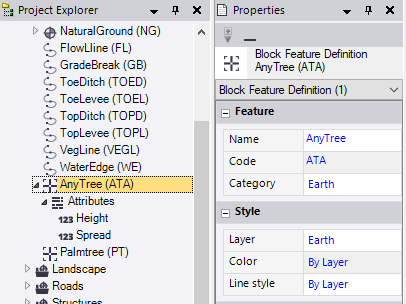
- Block feature definitions - A block feature is made up of one to three points that define the location and, optionally, the rotation around the Z axis and scaling on the X, Y, and Z axes for a CAD block. A block feature may also include block control codes that are used to specify rotation and scaling, and it may include one or more feature attributes.
Related block feature definitions are typically grouped in the same category (for example, all utility-related polygon feature definitions might be grouped together in a Utility category). You can edit the definition's properties (including how the block displays in graphic views) and supported attributes as necessary.
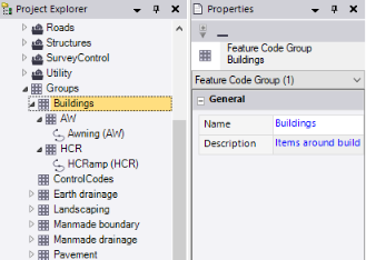
- Groups - Some field devices enable you to group a set of feature definition codes and control codes so that they correspond with a single button/action on the device. Multiple groups can be created from which field crews can select the one they need for the particular job.
- Line Control Codes - Surveyors can assign line control codes to points during field data collection to specify properties for an associated line feature. For example, they can assign a line control code to a point to specify where a feature line starts or ends. When the feature codes are processed, line control codes modify line objects according to the actions (instructions) associated with the code.
