Run an Earthwork Summary Report
Use the Earthwork Summary command to create a quick, simple earthwork report in a familiar Microsoft© Excel format. The Earthwork Summary contains just the takeoff estimation data you need to analyze and calculate a final construction bid. Compared to the full Takeoff Report, this summary:
- Calculates more quickly
- Provides more concise results that are easier to understand
For information on the standard Takeoff Report, see Run a Takeoff Report.
Note: Calculations can be performed using either surface triangles or with grid spacing you define; the reported values are based on the method you choose. These options also mean that direct comparison to other takeoff products may not yield an equivalent answer. See Compute volumes using grid below.
Note: You can set the on-grade tolerance for cut/fill in Project Settings > Computations > Surface Grid Label Settings > Zero area tolerance.
Prerequisites:
- You have calculated takeoff quantities within TBC, including defining site improvements and materials. Ensure that you have worked through each of the applicable commands in the takeoff workflow so that the data needed for the report will be complete.
- See the Subscription Plans page. For a license matrix by command, see the License page in the TBC Community. Also see View and manage licensed features.
To access the command:
- Select Earthwork Summary in Takeoff > Report.
To generate an Earthwork Summary report:
- In the Initial surface list, select the surface that reflects the state of topography before the surface you select as the final surface below.
- In the Final surface list, select the surface that reflects the state of topography after the surface you select as the initial surface above.
- If you have an overexcavation surface that you want to include in the calculations, select it in the Overexcavation list. It will be used in calculations regardless of how the Active flag is set in the surface's properties. The Initial and Final surface above are both are required, but this overexcavation surface is optional.
- Strata - Specify which stratum should be reported on:
- None - Ignore all strata and report only on final values per boundary.
- Use takeoff strata (comp/ratio based on materials) - Report on each stratum that is defined per boundary.
- Selected (comp/ratio based on materials) - Select a Strata surface and Material to report on in the lists.
Note: If the Earthen Material option in step 3 is set to Do not apply, the Material list (just above) is not shown and material density properties are set to no swell or shrinkage.
You can define density properties for the material between the initial and final surfaces (not accounting for strata) or above the top-most strata (use takeoff strata), or have the report run without them (resulting in a cut/fill ratio of 1.0).
Note: Options in this group are enabled/disabled based on your selection in the Strata group below.
- Select an option in the Earthen Material group:
- Do not apply - Do not apply and material density factors (swell and shrinkage factors are 1.0). Selecting this will remove the compaction cut/fill ratio and compaction volumes from the volume table.
- Define material - Use material density factors applied to existing materials to define properties of in-situ material and borrow materials:
- Native/Existing material - Select the uppermost earthen material of the original ground surface or native material that exists on-site.
Note: Before using this option, you need to have defined surface materials in the Material and Site Improvement Manager.
Note: If no subsurface earthen material strata have been defined, the Native material control will be enabled, allowing a single representative earthen material to be identified. Otherwise, the materials associated with the defined strata will be employed as they are encountered via excavation, and the Native material control will be disabled. - Borrow/Fill - Select a material to be obtained from off-site sources should there be a net deficit in material/a non-native material that must be brought from off-site.
Note: 'Borrow' is occasionally used to refer to materials that exist on-site, but in a location far from where they need to be placed.
Note: The next two options below are disabled/unavailable if you have Use takeoff strata selected in the Strata group below.
- Native/Existing material - Select the uppermost earthen material of the original ground surface or native material that exists on-site.
- Define comp/ratio percentages - To account for shrinkage and bulkage (swell) of materials, specify as percentages (relative to zero):
- Swell (cut) % - Enter a percentage to account for the increase in volume and decrease in density of soil (or another material) due to expansion. Bulkage/swell is a common result when soil at its original insitu density is excavated from a job site and moved elsewhere during construction activities.
- Shrinkage (fill) % - Enter a percentage to account for the decrease in volume of soil (or another material) due to contraction, settling, and compaction.
- Define comp/ratio factors - To account for shrinkage and bulkage (swell) of materials, specify as direct multiplication factors.
- Swell (cut) factor - Enter a decimal value to multiply volumes by to account for bulkage.
- Shrinkage (fill) factor - Enter a decimal value to multiply volumes by to account for shrinkage.
- Select an option to define the geographic coverage of the report in the Report Boundaries group:
- Entire site - Run volume calculations on the entire site, separating by area of interest (no AOI column appears in any table).
- Include and report takeoff AOIs - Report on each AOI and the site individually. If you have not defined any AOIs, then the entire site is reported (same as above).
- Selected - Pick one or more closed lines or AOI borders to use as boundaries. Each bounded area is reported separately.
- Check boxes to set additional Report Options:
- Compute volumes using grid - Takeoff calculations run faster when you opt to approximate surfaces with a mesh of squares, rather than surface triangles. Define the grid size in project units (defaults grid sizes are 5.0' (Imperial) and 2.0 meters (metric).
- Shade report titles - Add background fill color to column headers to make them easier to visually find.
- Only report site improvement subtotals - Restrict the volumes section to include only site improvement subtotals and totals. This significantly reduces the volume table sizes when many site regions and/or material strata are defined in your model.
Note: When this box is checked, strata selected for calculations is still used, but not reported.
- Only show site improvement region name (when available) - In the Volume Report table (see below), the name of each site improvement follows this format:
Site improvement name (site region name).
(for example)
4" Topsoil Replacement (Topsoil Replacement Area)Check this box to show just the the site region name.
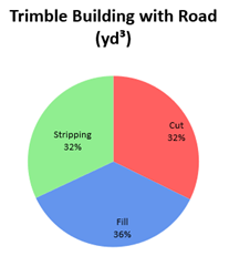
- Include pie chart of volumes - Generate a table of earthwork volumes along with a pie chart showing the relative percentages of the materials (cut/fill/stripping).
- Include site regions - Report on volumes for each site region (otherwise the Job Total is shown in the final report)(report by site improvement from the finsh surface).
- Include topsoil handling - Include the Topsoil Stripping and Topsoil Replacement summary tables in the report.
- Include material totals - Include area, volume, and supplemental units (if applicable) for each material type in the report.
- Merge the topsoil out volume into the first line - Shortens the Volume Report table. For each site improvement with strata, the fill volume only ever appears on the Site Improvement line and that line never contains any cut values. The second line is always the general topsoil (materials are reported from highest elevation to lowest, so topsoil is first). With this option enabled, the topsoil material values are placed on the site improvement line, and the Topsoil line does not appear. This results in one fewer line per site improvement.
- Click Apply. After running, the report opens in Microsoft Excel.
|
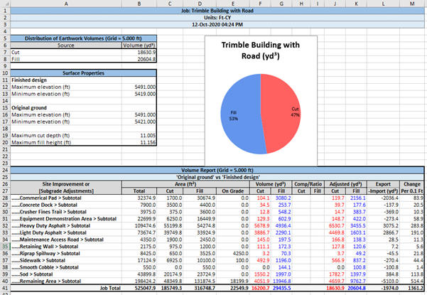
Report Sections *denotes tables shown by default if you deselect all options. These summaries are generated regardless of which report options you choose. Together they show a complete, high-level description of the earthworks in the project, including statistics for area and material volumes, demolition, and site improvements. The report contains these tables: |
|
| Distribution of Earthwork Volumes |
Shows the total cut volume and total fill volume (based on the grid size shown (Grid = ft/m). If you select the Include topsoil stripping option, it will also show the stripping volume. The Volume Chart mentioned below shows these volumes as percentages of the total. |
| Surface Properties* |
Shows the minimum and maximum elevations of the Initial and Final surfaces, as well as the maximum cut depth and fill height. If you select an overexcavation surface also, this section shows the above values for that surface as well. |
| Volume chart |
Shows the percentages of cut and fill volumes as a pie chart. If you select the Include topsoil stripping option, it will also show a Stripping % slice.
|
| Volume Report* |
Separately lists the cut/fill areas and volumes for each of the included site improvements and provides subtotals by site improvement, plus:
The Volume Report section includes subtotals per site improvement type (e.g., Pads Subtotal) in the Site Improvement (or Subgrade Adjustments) column. |
| Stripping Quantities |
Shows the topsoil stripping and replacement by AOI, with site improvement areas (both planimetric and sloping), material depths, and volumes. Note: This table uses the name of the boundary linestring, so ensure that it is appropriately named. |
| Existing In-Ground Demolition |
Shows site improvement areas, material depths, and volumes and their materials (in red text on the row below the site improvement) to be demolished from the original ground/initial surface. When portions of the original ground surface contains materials (such as in a concrete pad) that needs to be demolished and removed. Just like adding a site improvement for a concrete pad to a design, these materials can be considered as demolition. These volumes are reported in this table and are not included in the topsoil removal or Sectional Quantities table. Also see the description of Supplemental Units below. |
| Sectional Quantities* |
Shows non-topsoil site improvement areas, material depths, and volumes. Areas, lengths, and counts are reported in separate sections (Area-, Length-, and Count-based Site Improvements).
For example, if you calculate grass seed that you need to spread by square meter, but must purchase it by bag, then type "bag" here. If you entered "bag" as the supplemental measurement unit so it shows "1 cubic meter = 1.5 bags", but you want to enter the values as "1 bag = .666 cubic meters", you will need to check the box. |
| Material Totals |
Shows the total volume of each material (regardless of its site improvement) in cubic and supplemental units. |