Create a Surface Elevation Grid
Use the Create Surface Elevation Grid command to create a grid that labels the elevations of a surface.
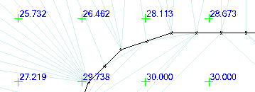
Use surface elevation grids in conjunction with contour lines to make changes in terrain more evident.
Prerequisites:
- Surface
To access the command:
- Select Create Surface Elevation Grid in Surfaces > Create.
To create an elevation grid:
- Select the surface on which the grid will be based in the Surface list.
- Select the layer on which you want the grid to reside in the Layer box, or select <<New Layer>> to create a new layer for the grid.
- Select a style that controls the text font, font style, justification, and size for the grid annotations in the Text style box, or select <<New style>> to define a new text style.
- In the Grid spacing box, type a value for the uniform interval at which the grid lines or tick marks for the measurements will be spaced.
- Select an option for how the location of each measurement will be denoted in the Grid style box.
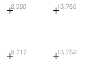
- Select the number of decimals to use in the measurement in the Decimal precision list.
- Click . The elevation grid is created and appears in graphic views and the Project Explorer. Additional properties, such as the grid's insertion point, and rotation, and colors can be set in the Properties pane.
Options:
These options and additional settings for a surface elevation grid are also available in the Properties pane.
|
|
||
| Surface |
For an elevation grid, select the surface for which you want to see elevations. |
|
| Layer |
Select the layer on which you want the grid to reside. |
|
| Text style |
Select a style that controls the text font, font style, justification, and size for the grid annotations. |
|
| Grid spacing |
Type a value for the uniform interval at which the grid lines or tick marks for the measurements will be spaced. |
|
| Grid style |
Select an option for how the location of each measurement will be denoted: |
|
|
Ticks |
|
|
| Decimal precision |
Select the number of decimals to use in the measurement. |
|

Scenarios:
- If you add an elevation grid to an alignment-based surface (like a corridor), the number of of grid locations is based on station and offset values, not X,Y values.
Dependencies:
- The elevation grid is a dependent object; it will dynamically update in response to edits made to the related surface.
