Units
Use the Units settings to change project units, entry formats, and display formats for:
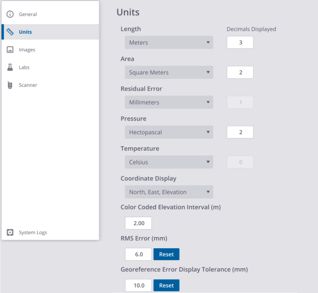
LENGTH: Select whether to work in Metric or Imperial units. If Feet, specify whether they are US Survey Feet or International Feet.
AREA: Select whether to work in Metric or Imperial units.
RESIDUAL ERROR: Select whether to work in Millimeters, US Survey Feet or International Feet.
PRESSURE: Select whether to work in Millibar, Hectopascal, Milliliter of Mercury or Inch of Mercury for displaying atmospheric correction values (for an X9 only).
TEMPERATURE: Select whether to work in Celsius or Fahrenheit for displaying atmospheric correction values (for an X9 only).
COORDINATE DISPLAY: Select whether to work in the (X,Y,Z) coordinate system or in the (N,E,El) coordinate system.
COLOR CODED ELEVATION INTERVAL (m): This number defines an interval in meters when applying the Color Coded Elevation rendering to the data displayed in the Map View (see Visualize Scan Data > Map View). The Color Coded Elevation renders the data with the height information encoded in the point color. This helps to visualize instantaneously the height of points in a scene. This rendering is useful to highlight e.g. in a building each floor separately, repeating the color bar at each level.
You need to be in the Right (or Left) view to see the Color Coded Elevation rendering applied.
RMS ERROR (mm): This is an adjustable threshold that is used when refining a project. See Refine a Project (or Registration Set(s)).
GEOREFERENCE ERROR DISPLAY TOLERANCE (mm): This is an adjustable threshold that is used when georeferencing a project. See Georeference a Project.
