Validate Site Improvement Areas
The formation of area-based site improvements as a result of the categorization of layers (as required to run a Takeoff Report) can get quite complicated as a result of the region logic used in order to accommodate circumstances where a site improvement of one type may be wholly encompassed within the boundary of one of another type, or those in which the two site improvement boundaries overlap. After assigning area-based site improvements to the appropriate layers using the Categorize Takeoff Layers command, one should always execute the Validate Site Improvement Areas command to confirm that the area attributed to each site improvement correctly adheres to your expectations. It will created shaded polygons within the Plan View, attributable to each site improvement, thereby providing a crucial quality control asset.
Note: Using this command is primarily useful when you have assigned area-based site improvements to layers through the Categorize Takeoff Layers command. If you assign area-based site improvements using the Assign Site Improvements command, you can validate area as you assign them.
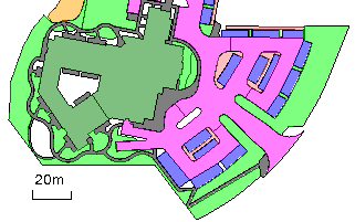
This command provides a quick, visual confirmation of the areal coverage of each area-based site improvement, , which could potentially differ from your expectations based on your understanding of the original data and the rules by which the noted region logic is applied. It is recommended that you always run this command when you intend to run a Takeoff Report. This visual feedback is a quick and easy way to eliminate takeoff errors.
The validation can be done separately for the Original, Design, and Other takeoff categories, as defined in the Categorize Takeoff Layers command. The shaded polygons that are created represent each area-based site improvement. The colors and elevations of the polygons are derived from the uppermost material layer. Open the Material and Site Improvement Manager, select a material and set the color so that each material can be determined by its color.
Note: Area-based site improvements that are categorized as Original will be considered as being slated for demolition, if they contain one or more non-zero thickness, subgrade material layers.
Prerequisites:
- License; See the Subscription Plans page. For a license matrix by command, see the License page in the TBC Community. Also see View and manage licensed features.
- One or more area-based site improvements that have each been assigned to a takeoff category
To access the command:
- Select Validate Site Improvement Areas in Takeoff > Site Improvements.
To shade area-based site improvements:
- In the Takeoff Category group, select the category to which the area-based site improvements that you want to validate are assigned (see Categorize Takeoff Layers for more information).
- Select the layer on which you want the shaded polygons to reside, or select <New> to create a new layer.
Tip: You probably want to change the layer for each takeoff category; see the note after the last step.
- In the Fill transparency box, specify a transparency percentage for the polygon's shading (0 = opaque; 100 = completely transparent/invisible). Since the polygons are on top in the stack order, this setting affects the visibility of objects under the polygons.
- To restrict the shading to a specific area of interest (AOI), check the box for that AOI.
- Click Apply. Shaded polygons are created in the Plan View, and the number of areas that were shaded is reported in the Results group.
- Repeat the steps above to create shaded polygons for area-based site improvements that are assigned to different takeoff categories and/or AOIs.
Note: Each time you rerun the command for a specific takeoff category, the previously created polygons for that category's layer are replaced so that you do not get duplicate polygons.
Note: Each polygon is named for its related site improvement. You can identify a polygon by hovering over it or picking it when the Properties pane is open. - Click Close.
Scenarios:
- If you find that areas that you expect to be shaded are not (no polygons were created), check your data for the types of situations described in the Area-based Site Improvements section of the Understanding Holes, Islands, and Overlapping Areas help topic. Areas that are not shaded are not being counted with a material in your takeoff calculations!
Dependencies:
- None; the command shades areas based on the geometry of the current area-based site improvements. If you change the improvements or their geometry, the shading does not update until you rerun the command.
