Check Imported Surfaces
You can import surfaces existing in Trimble DTMs (.ttm), LandXML files (.xml), SiteVision design files (.svd), Terramodel project files (.pro), or ASCII point files. Once you do, check the surface for quality and accuracy.
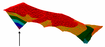
Example of a surface with a point at an invalid elevation.
To check an imported surface:
- Add contours to visualize the topography of the surface.
- Spot check elevations. Pick a point in a graphic view to find the elevation of the surface at that location. The coordinate scroll also shows the elevation of the current cursor location.
- In the 3D View, orbit around the surface and zoom in to see it everything looks valid. If it helps, change the vertical exaggeration.
- Pick the surface and view its properties in the Properties pane.
Note: To see the slope direction of each triangle in a surface, set Slope arrows to Show in the properties for a surface. To specify the length of the slope arrows, select Project Settings in the Quick Access Toolbar. Then click Computations and Surface in the left pane. Change the value in the Slope arrow length box.
