Understanding Points and Coordinates
Use these definitions to understand the differences between the various types of points and point properties in your project.
|
|
|
| Point |
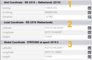
A point is a named object that represents a location with either local or global latitude and longitude coordinates, and possibly a height or elevation. Points are usually measured in the field and then brought into a project by importing them in a GPS, GNSS, or points file (.dat, .T01, .pts or .csv), but they can also be created in this software. When you create a point in this software, it contains a single coordinate that is identified as "Office entered". A point can contain multiple coordinate objects, each with a different location and quality. See Coordinate below. You cannot edit a point directly, you must edit one or more of its coordinate objects. If it does not have a coordinate object, you must add one. CAD points can, however, be edited directly. The term “point” may also be used generically to mean a coordinate (essentially a location in 3D space). When you are asked to specify a “point” in this software, it often means that you can specify a coordinate or a named point as described above. |
| CAD point / Lightweight point |
A CAD (or lightweight) point is a simple, unnamed object that represents a location with grid (X,Y) coordinates and possibly height or elevation (Z) value. Because CAD points do not include global and local latitude and longitude coordinates like regular points, they are non-transformable; if you change your coordinate system, grid points do not move. Unlike points, CAD points can be edited directly in the Properties pane. CAD points are brought into a project by importing them in a CAD file (.dxf, .dwg, .dgn, or .svl); they cannot be created in this program. |
| Point ID |
A point ID is the identifier of a named, field-observed or office-entered point object (see Point above). |
| Coordinate |
A coordinate is a pair of X and Y or northing and easting values (in 2D), or a set of X, Y, and Z or northing, easting, and elevation values (in 3D) that defines a location in 3D space. If only two coordinates are given, the Z value or elevation may be 0 (relative to the current coordinate system) or may be undefined. When a coordinate is required in this software, you may be prompted to specify a “location” or a “point”. Read-only point coordinates are displayed in the Points Properties pane |
 as shown here...