Understanding Point Types
The software supports two basic types of points:
- Normal points are created when you import into your project any type of point data other than coordinate point data contained in a text file (for example, .csv) with "Unknown" or "Mapping" quality. You can also create normal points manually using the Create Point command.
A normal point includes one or more coordinate and/or observation nodes nested beneath it in Project Explorer that are used to compute the coordinate for the point. You can edit values for coordinate nodes, or change the coordinate quality level, in the Properties pane. These changes are reflected in the read-only coordinates displayed for the point in the Properties pane.
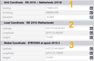
Read-only point coordinates are displayed in the Points Properties pane
 as shown here...
A specialized type of normal survey point is an "as-staked" point. This is a point that was staked in the field based on a design specification. The as-staked point is typically imported into a project in a JobXML (.jxl) file along with its corresponding design point and computed delta values. Trimble Business Center flags any as-staked points whose horizontal and/or vertical deltas exceed the tolerances you specify in Project Settings. For more information, see View As-Staked Point Data.
Another specialized type of normal point is a "measure-to-surface" point, which is an imported point that includes a measurement to a specified surface. This enables you to, for example, easily compare topo shots to an original ground surface model, or measure the clearance from the top of a tunnel to the road surface. For more information, see View Measure-to-Surface Point Data.
- Lightweight points arecreated only when you import a text file (for example, .csv) containing coordinate point data with "Unknown" or "Mapping" quality (for example, topographic points).
A lightweight point does not include coordinate nodes nested beneath it in Project Explorer. A non-editable coordinate is displayed for the point in the Properties pane.
Note the following concerning lightweight points:
- You can add an editable coordinate to a lightweight point by right-clicking the point in Project Explorer and selecting Add Coordinate. This changes the lightweight point to a normal point.
- If you import a text file with "Unknown" or "Mapping" coordinate quality into a project that already contains point data, duplicate points will be created for points in the text file (lightweight points) and points already in the project (normal points) that have the same ID (that is, points will not merge as expected). To avoid this problem, import the text file first to create the lightweight points in the project, then import the other point data. The lightweight points from the text file will merge with the normal points from the other point data to create normal non-duplicated points.