View Aerial Photogrammetry Data
You can view aerial photogrammetry data in Trimble Business Center in a variety of locations, depending on your needs.
To view aerial photo station data in the Project Explorer:
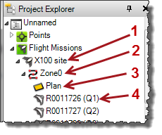
Each flight mission in the project is represented by a Flight Mission node (1 in figure below). Nested beneath each Flight Mission node is one or more Flight Block nodes (2). Nested beneath each Flight Block node is a Flight Plan node (3) and multiple Aerial Photo Stationnodes (4), each representing an aerial photo station included in the block.
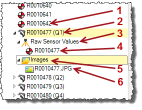
Each imported JobXML (.jxl) containing aerial survey data is represented by a File node nested beneath the Imported Files node. Nested beneath each File node are Coordinate nodes (1 in figure below) and Aerial Photo Station nodes (2) representing the data contained in the file. Nested beneath each Aerial Photo Station node is a Raw Sensor Values node (3), which includes a nested Coordinate node (4) and an Images node (5). Nested beneath each Images node is a Referenced Image node (6). Each Coordinate node represents an unadjusted coordinate recorded by the aerial photo station using autonomous GNSS. Each Referenced Image node represents an image recorded by the aerial photo station.
Note: You can right-click the Imported Files node in the Project Explorer and select to sort the imported files either by their name or by the order in which they were imported, providing two options to more easily locate any imported file.
Click any node to select it (if applicable) in a graphic view or spreadsheet view. Double-click any node to view its properties in the Properties pane. Right-click any node to see a context menu of related commands.
To view aerial photo station data in graphic views:
In the various graphic views, you can view and select the following:
Note: For optimal viewing of aerial imagery, try selecting Project Settings in the Quick Access Toolbar and then selecting View > Referenced Image and choosing 75m for the Viewing distance.
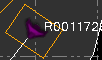
- Flight Mission - Represented by a selectable boundary box around the aerial photo stations included in the mission.
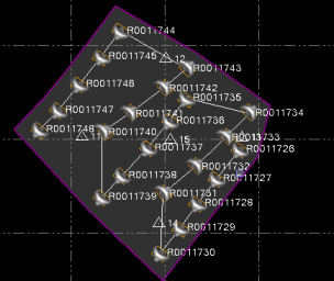
- Flight Block - Represented by a selectable connecting line running through each aerial photo station included in a mission. A single flight mission can include multiple flight blocks.
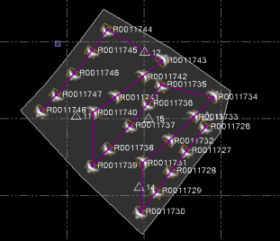
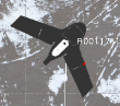
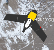
- Aerial Photo Station - Represented by a aerial photo station icon with a flight block connecting line running through it. The aerial photo station icon points in the direction the unmanned aircraft system (UAS) was traveling when the image was recorded. In addition, its color changes from black to white when a station adjustment has been performed.
Before adjustment:
After adjustment:
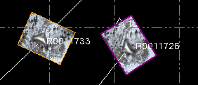
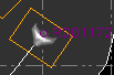
- Referenced Image - Represented by a rectangular box around an aerial photo station.
If the Referenced Image (Plan View) option is selected in the View Filter Manager, the image is displayed with each station in the Plan View as well. This is helpful in ensuring images are correctly rotated, are located at the correct position, and are not corrupted.
Select Project Settings in the Quick Access Toolbar. Then select Referenced Image to specify default settings for referenced images displayed in the Plan View. Or view the Properties pane for any specific referenced image to select display settings.
- Point - Represented by a point icon.
To apply view filters:
- Select View Filter Manager in Views > View.
- In the View Filter Manager, select to display or not display photogrammetry objects in graphic views by making selections in the Photogrammetry section of the View Filter list.
- To specify whether a photogrammetry object is selectable in graphic views, do the following:
- Click the Advanced View Filter Settings button in the View Filter Manager toolbar.
- In the Advanced View Filter Settings dialog, select to make photogrammetry objects selectable or not selectable in graphic views by making selections in the Photogrammetry section of the Advanced View Filter list.
