Intersection Leg Properties
By default, legs are numbered Leg 1, Leg 2, etc., but if necessary, the name can be defined more specifically. Every leg of a road intersection can have properties in these groups:
- Road Intersection Leg
- Corridor Data
- Lane widening
- Island General (these properties may have some slight differences from type to type)
- Island Specific (these properties will be different for each type of island)
|
Selected Leg Properties |
|
| Road intersection leg |
Alignment/Corridor - Shows the road object to which the leg is connected. Main road leg - Use this to define the leg as the primary road leg or not (Yes/No). This influences how the vertical alignment is vertically adjusted in the Road Intersection. Main road leg pair - This is the reference pair of the main road leg (requires two main road legs). Vertical adjustment method - Select a method for the vertical adjustment of the road leg alignment.
Vertical adjustment length - This shows the distance from the connection to the main road lane outbound along the leg. Minimize road leg - As a standard definition, the road leg is minimized automatically (Yes). This option computes the shortest necessary length to the current leg. The minimized length will change depending on the other properties given to this leg. If No is selected, another property is shown: Length from center - This defines the total length of the leg that will be computed. The maximum length is the total length of current leg. The minimum length will depend on combinations of other properties, but cannot be shorter than the automatically minimized length of the leg. Road leg type - Two way is the default for a scenario in which the connecting road supports traffic moving in both directions (incoming and outgoing). |
| Corridor data |
Station interval - Specify the distance you want between surface cross-sections along the alignment. The surface is sliced at the interval you specify to create the cross-sections. The nodes that will be reported on are where the cross-section intersects with surface triangle edges. If you have defined a corridor template, then this information should be used to define the intersection. If you do not have a template defined, then the following section will be included and will be used to define the intersection. Any change here automatically changes the intersection. When using corridors, there is currently no way to specify how nodes connect to each other. This can be limiting in how complex intersections can be formed. |
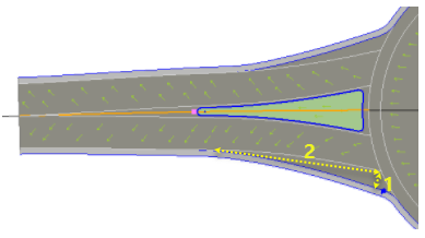
| Lane widening |
Widen left/right lane - Set this to Yes if you need to widen the exit lane (left/right) of a leg where it joins to a roundabout intersection. The figure below shows widening of the right lane of a roundabout leg; either side can be widened where the leg enters the roundabout. Figure: Roundabout lane widening
Extra width left/right - Specify the extra width (1 above) of the exit lane at the front of the leg where it joins to the roundabout. Transition length left/right - Specify the distance (2) over which the extra width is added to the exit (left/right) lane. |
| Island general and Island specific | |
|
Separator and Turn Lane |
|
|
|
These two road island types also use a property to define the front of the island, as measured from the center point: Length front - This shows the distance from center point of the intersection to the tip of the road island. For more information, see Intersection Turn Lane Properties. |