Preparing your data
Good data preparation is the essence of great visualization. As the SiteVision system supports a wide range of data types for a wide range of users, this section describes a range of typical workflows and discusses the benefits and limitations of different types of data and data preparation.
About model complexity and size
SiteVision features a powerful 3D visualization engine that allows it to load and display large and complex models, reducing the burden in terms of data preparation. This reduces the likelihood you will need to section your models into smaller pieces before loading into the application.
NOTE –Depending on your use case you may still prefer to organize your data by sectioning it—for example, by floor. As there is no way to occlude the display of data behind physical walls / floors, it can be confusing to see data from the level above or below. Conversely, this can also be very helpful if you want to visualize a services riser traveling up through multiple levels, or to see what is behind a wall.
There are still limitations on how much data can be rendered at any given time; this limit is dependent on the device you are using. The more modern a device is, and especially the quantity of RAM, will be the governing factor.
One of the methods SiteVision uses to improve performance is to hide any small objects that are more than 8 m (24 ft) away from the current viewing position within the model. These small objects are typically bolts, or other physically small objects, which due to their size are difficult to see from a distance. Moving around within the model dynamically redraws these small objects so you will always see them in your vicinity so that you always see all your model content within 8 m (24 ft).
In some extreme cases, typically very complex and dense models, and especially if running on an older device, SiteVision may not be able to render all the objects within 8 m (24 ft). In this situation the following banner message displays notifying you that some objects may be missing from the visualization.
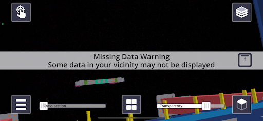
To manage this you can turn off unnecessary model data from the layers menu. As you disable each layer, SiteVision will reoptimize the visualization and once sufficient layers have been turned off that all data can be displayed, the banner message will disappear.
SiteVision has a maximum rendering distance limit. Only data within 10 km (approximately 6 miles) is displayed; data beyond this distance is not visible.
Supported data formats
The table below lists the supported data formats from Trimble products, open industry standards, and third party software.
|
Supported Data types |
||||||
|---|---|---|---|---|---|---|
|
Format |
Points |
Lines |
Surfaces |
Attributes |
Textures |
Alignments |
|
VCL* |
X |
X |
X |
X |
X |
X |
|
TTM |
|
|
X |
Image overlay |
X |
|
|
TMAPS |
X |
X |
|
X |
|
|
|
SKP |
X |
X |
X |
|
X |
|
|
TRB |
X |
X |
X |
X |
X |
X |
|
LandXML |
X |
X |
X (TBC only) |
X |
|
X |
|
IFC (2x3, MVD EM.11) |
|
X |
X |
X |
|
|
|
OGC WFS |
X |
X |
|
X |
|
|
|
SHP |
X |
X |
|
X |
|
|
|
GDB |
X |
X |
|
X |
|
|
|
DWG |
X |
X |
X |
|
|
|
|
Esri WFS |
X |
X |
|
X |
|
|
|
NWD / NWC |
|
X |
X |
X |
|
|
*VCL format refers to the export from Trimble Business Center using the SiteVision AR Exporter plugin. This generates the VCL, TRB and calibration files.
This section describes:
