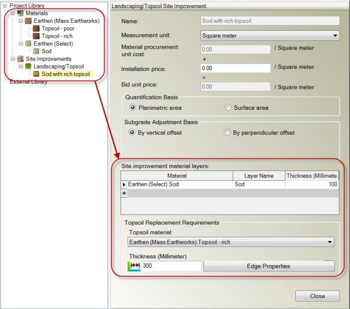
Landscaping/Topsoil Site Improvement Options
Landscaping/topsoil site improvements can be assigned to enclose site regions within which the improvement's area and material volumes can be calculated. A grassed parking island is an example of a landscaping site improvement. In addition to procured material layers needed for area-based landscaping site improvements (such as sod, grasses, shrubs, weed-block fabric, and fertilizers), this category enables you to associate previously stripped topsoil (or topsoil imported from off site) of a nutrient rich grade for use as bedding beneath the top level of landscaping material layers.
Such a site improvement might be represented like this:
In the Takeoff Report, both the area of each instance of the site improvement and the total area of all instances are reported. The cost of the cumulative total area is also calculated, if you provide unit cost data for each individual area. The report can also be configured to account for replacement topsoil and the use of excess topsoil separately within the Topsoil Handling section.
|
Options |
|
| Name |
Type a descriptive name for the site improvement as you want it to appear in the Identify Site Regions command and the Takeoff Report. |
| (optional custom field) |
To include a user-defined field, visit Project Settings > Custom Fields > MSI Manager. See Custom Field Settings for details. |
| Measurement unit |
Select the appropriate unit of area measurement. Note: The units of measure that you specify overrides the corresponding setting in the Units section of Project Settings. |
| Material procurement unit cost |
This displays the total of the procurement unit costs of those materials that are directly associated with the landscaping, based on their area or volume as appropriate. These are defined in the Site improvement material layers at the bottom of the pane. Note: This program displays the currency symbol and format that you have set in Microsoft Windows® Regional and Language Options. The units and calculations, however, are not associated with a specific currency, so if a project is opened on a computer with different regional settings, those currency symbol and formats are used, but no conversion between currencies has been made. |
| Installation price |
Enter the cost (per area unit) that you will charge the customer to furnish, install, or otherwise construct every aspect of the site improvement, including all labor costs, profit, and other incidental costs that you expect to pay to have the site improvement constructed. |
| Bid unit price |
This displays the total of the material procurement unit cost plus the installation price for each instance of the site improvement. This total, which can be reported in the Takeoff Report, is the price per unit area of this site improvement on which you intend to base your bid. |
| Quantification basis |
Planimetric area - Select this to have the planimetric area for the site improvement calculated and reported in the Takeoff Report. Surface area - Select this if the actual surface area (from the surface triangles) of the site improvement is important, such as for sodding on a slope. Surface area for the site improvement will be reported in the Takeoff Report. |
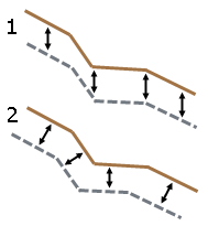
| Subgrade adjustment basis |
By vertical offset - Select this if the site improvement's top and bottom surfaces are to be vertically offset from each other (1 in the graphic below). By perpendicular offset - Select this if the site improvement's top and bottom surfaces are to be perpendicularly offset from each other (2 in the graphic below).
Figure: Vertical offset versus perpendicular offset |
| Site improvement material layers |
Enter the surface and subsurface materials needed to build the site improvement in the order they will be laid from top to bottom.
|
|
Topsoil Replacement Requirements |
|
| Topsoil material |
Select an earthen (mass earthworks) topsoil material. Only those classified as Usable for topsoil replacement will be listed. This is for reporting topsoil replacement volumes in the Topsoil Handling section of the Takeoff Report. |
| Thickness |
Specify the constant thickness at which the topsoil replacement layer is to be placed. |
|
Edge Properties |
|
| Edge configuration |
Vertical - Select this to use a 'vertical' edge of the topsoil replacement and/or excess topsoil earth fill layers, where the topsoil transitions to structural fill materials. This simple approach may not reflect the actual construction, but provides a basic model and volume calculations. Sloping - Select this to specify a sloping edge for the topsoil layers. This approach reflects better construction practices, providing adjacent site improvement subgrades with a more substantive foundation, bearing on stable, structurally sound earthen materials. Note: If the topsoil abuts a site improvement with a vertical edge (such as a building foundation or sidewalk) the topsoil's edge will be vertical to the bottom of that site improvement. From that depth down, it will be sloped. |
| Slope |
Specify the cross-slope for the edge of the topsoil. To use a method besides the default, click the
Note: The ratio you specify depends on the Slope ratio type defined in Project Settings > Units > Vertical Angle. |
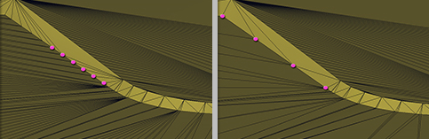
| Maximum spacing |
Specify the interval of vertices around the edge by entering the maximum distance between each line (drawn from the finished design level to the Finished design with topsoil absent surface.
Figure: Maximum landscaping/topsoil edge spacing |
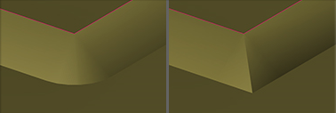
| Outside corner tie method |
Round - Select this to produce a conical projection from an outside corner point, resulting in a generally rounded corner. Sharp - Select this to produce a mitered solution where the sideslopes are extended to their intersections.
Figure: Round versus sharp corner projections for topsoil edge |