Identify Site Regions
Use the Identify Site Regions command (previously called Assign Site Improvements) to assign area-based site improvements and/or simple subgrade adjustments to site regions. Site regions are shaded as you assign site improvements to them, enabling you to quickly confirm that they fill the intended area.
Note: You can also assign a particular area-based site improvement to all closed lines found on a specific layer through the Categorize Takeoff Layers command, but the method described below has unique benefits. For example, the slope area (not just the planimetric) is calculated for the site improvement areas assigned using this method.
Understanding potential region boundaries
The Categorize Takeoff Layers command allows you to designate layers that are expected to contain lines that may serve as boundaries for area-based site improvements. All such lines are referred to as potential site improvement boundary lines.
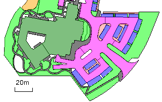
When you select a Takeoff Category in the Identify Site Regions command, a message such as "32 potential boundary line objects were found." is shown. A boundary (in this context) is a closed line or a combination of lines (or portions of lines) that, taken together, form an enclosed region. An area-based site improvement must lie within such an enclosed region. It is important to understand that that there can be a significant difference between the concept of:
- a boundary
- the lines themselves, perhaps only portions of which may contribute to the formation of an enclosed region
- the candidate boundary lines that the program has determined to contribute to the formation of viable enclosed regions, each of which may comprise only a portion of the source line objects
The message that displays is simply reporting the number of line objects that have been found to exist on the layers that have been designated as potentially containing site improvement boundary lines associated with the selected takeoff category.
While the Identify Site Regions command is running and a suitable takeoff category is selected, all lines that are found to be on layers designated as potential region boundaries can be highlighted in two ways:
- When the Highlight all potential boundaries box is not checked: Portions of boundary lines that have been determined to form enclosed regions are highlighted in orange. The remaining portions of potential boundaries can be highlighted by checking the above box.Those portions of the lines that have been determined, on the basis of their geometric relationships to others, to form enclosed regions, are referred to as candidate site improvement boundaries. They are highlighted orange.
- When the Highlight all potential boundaries box is checked: Candidate portions of boundary lines that have been determined to form enclosed regions are highlighted in orange. The remaining portions of potential boundaries are highlighted in magenta. Those portions among the potential boundary lines that have failed to be validated as candidate boundaries can optionally be highlighted magenta by checking the Highlight all potential check box.
Assigning Landscaping/Topsoil site improvements:
- Use the steps below, but see Define Topsoil Replacement Areas for more information.
Assigning simple subgrade adjustments:
Note: To assign count- and linear-based site improvements to layers, use the Categorize Takeoff Layers command. You can also assign area-based site improvements from within that command, but doing so requires that a closed line surround each site improvement.
Note: If you select Properties > Show in Plan View > Shading > By material for the Finished design or Original ground surface, that surface will display with the color of the upper-most material assigned to each site improvement. You have to rebuild the surface before the material will be shown.
Prerequisites:
- Licensed module; See the Subscription Plans page. For a license matrix by command, see the License page in the TBC Community. Also see View and manage licensed features.
- Layers that have been categorized and identified as potential area-based site improvement boundaries in the Categorize Takeoff Layers command
- One or more area-based site improvements (and the materials used in them) defined in your Project Library in the Material and Site Improvement Manager
To access the command:
- Select Identify Site Regions.
To assign area-based site improvements:
- If you have not already categorized and identified layers as containing potential boundary lines, see the Assign area-based site improvements section in the Categorize Takeoff Layers help topic. Once you have done that, open the Identify Site Regions command and proceed to step 2.
- In the Takeoff Category group, select the category that contains the layers you want to use as boundaries for area-based site improvements:
- Original
- Design
- Other
- Utility
The portions of the potential boundary lines that have combined with others to form enclosed regions are highlighted in an orange color.
Note: If area-based site improvements have been assigned (using either this command or the alternate method within the Categorize Takeoff Layers command), they will appear shaded when you select their category. For details on the differences between the two methods, see Understanding Area-based Site Improvements.
- To highlight all portions of all lines that have been identified as potential area-based site improvement boundaries check the Highlight all potential boundaries box. This shows the remaining portions, which were not found to contribute to the formation of enclosed regions, highlighting those portions in a magenta color. Doing so helps you to identify problems where a portion of a potential boundary failed to form an enclosed region, perhaps due to small gaps where portions of the lines that were supposed to form boundaries failed to intersect others.
- Select the layer on which you want the site improvement's seed point to reside in the Layer list, or select <<New Layer>> to create a new layer for it. The color of the layer does not affect the site improvement's color; the color is determined by the upper-most material layer used in the site improvement.
Note: If you find the Layer list disabled (grayed out), change the Action option from Remove identity to Identify region.
- Confirm that Identify region is selected.
- Select a site improvement that you want to assign to a region in the Site improvement list.
- If the site improvement type you need is not in the list, click the Browse button. The Material and Site Improvement Manager displays.
- Create the site improvement and click Close.
- Click in the Location box, and pick a point in the Plan View within the region that you want the site improvement to fill.
A site improvement indicator (dot) appears at the location and the region floods with the color assigned to the area-based site improvement (using a 50% transparency). Lines that are not identified as potential site improvement boundaries are visible, but not highlighted orange. You must pick a location encompassed by the highlighted lines.
- Repeat steps 4 - 7 for other site improvements in the selected takeoff category.
- If needed, select a different takeoff category and repeat the steps.
- Click Close when you are done. The site improvement shading is hidden until you run the command again. (Although if you have surface shading displayed, and the surface’s shading set to By material, the regions consisting of site improvements and subgrade adjustments will be shaded as a part of the surface.)
To remove area-based site improvements:
- Select the Takeoff Category to which the layers used by the site improvement are assigned.
- Click Remove identity in the Site region identification group.
- From the Location box, pick in the shaded region from which you want to remove the site improvement. The shading and seed point disappear, indicating that the site improvement has been unassigned from the region.
Note: If the shading does not disappear, the site improvement has been assigned using the alternate method within the Categorize Takeoff Layers command. See that command's help topic.
Options:
- Takeoff category - Select the category that includes the lines that you will use as boundaries for the area-based site improvements you are assigning. You must have previously identified the layers the lines reside on as potential area-based site improvement boundaries in the Categorize Takeoff Layers command. Lines that have been identified as such are highlighted in the Plan View.
- Explore current region - When your cursor is in the Location box, hover over any shaded region in the Plan View to see the name of the site improvement or subgrade adjustment that is assigned to it in this box.
- Gap closure tolerance - This displays the distance that lines will be extended to close unintended gaps when site improvement areas are being created within closed shapes. To change the tolerance, click the Project Settings icon on the pane's toolbar to open the Project Settings dialog.
Note: The Gap closure tolerance is a global setting applied to all regions each time the Identify Site Regions command is run. Changing this setting can affect previously assigned site improvements. If it is required that varying settings be used at the same time, then you should create closed lines using the Track Region Outline command and apply the site improvements to these new regions.
- Site improvement - Select the site improvement that you want to apply to a specific bounded region. If you are assigning landscaping site improvements with associated topsoils, see Define Topsoil Replacement Areas.
- Location - In this coordinate control, specify the point from which the site improvement (or color) will spread until it reaches a line identified as a boundary.
- Simple subgrade Adjustment - see Identify Simple Subgrade Adjustment Regions.
Scenarios:
- If you add additional lines to a layer designated as containing potential boundary lines used for a previously identified site improvement, the limits of the existing site improvements can change. Moving the existing boundary can cause the site improvement to select another region, if the designated seed point no longer lies within its former site region.
- If two layers have the same site improvement assigned to them, when two closed lines, each on a different one of those two layers overlap, the overlapped region is treated as a conflicting site improvement, and a flag is generated. In that case, a flag appears stating that “Area-based site improvements have been redefined.”
- When you rebuild your takeoff surfaces after identifying site regions, any errant site improvements associated with the Original ground or Finished design surfaces are flagged. The flags are shown in graphic views when the surfaces are shown, implying that the surface itself is flagged. The flag, however, is actually displayed on the site improvement at the surface's elevation.
Dependencies:
- The extents of a site improvement (and its subsequent volume calculations) are dependent upon the lines that encompass it. If you change those lines, the site improvement is updated.
Validating site improvement areas
You can still use the Validate site improvement areas command to create shaded polygons, but this is no longer recommended as they are different objects than site improvements, and they do not update to reflect subsequent edits.
